

There are many canals connecting home owners to Tampa Bay. This is Tom's son's (T.Michael) house in the Baycrest area. Much like the Bay itself, there's not enough water to float a boat. So why did folks have to evacuate? Let me try to explain. If you live near water anywhere along the Gulf coast, NHC has to OVERWARN since the evacuation process is typically days. Models try to forecast the track 5 days out, but we all know there is still errors in track forecasting. So let's review the track.


The green line in the top photo is Ian as a Tropical Storm with the orange being a hurricane and the deeper orange being a major hurricane. Before the storm became major, I grabbed the track prediction issued on September 23(bottom pic). Wow, 5 days out and NHC hit the bullseye. However, due to shifting model information, NHC shifted the center line track westward focusing in on the Big Bend area. Remember, the GFS had Ian hitting Pensacola! So that was why the warnings were extended all along Florida's west coast.


But what happened once Ian reach the Gulf? Models started an eastward shift, but the evacuation orders were all ready in place and hundreds of thousands were already on the roads out. Should NHC cancel the warnings north of Tampa? Remember, Tampa was once the bullseye. Can't do, the risk is still there for a track shift/wobble. By the time Ian's track was locked, it was only a day out. I thought NHC did a tremendous job with a very difficult moving storm. This was not just a Hurricane. This was a MAJOR Hurricane. Communities have to understand, for every 5 storms you have to evacuate, 4 will end up being for no reason at all. The UNCERTAINTIES in track forecasting will always mean NHC will over warn on the side of caution. For nearly 4 decades I educated my viewers on the importance of following the center line track. IF you can stay on the weaker side and stay outside the EYEWALL, impacts usually are minor. However, if you are on the right side of the track, that is where impacts will be most severe. Here's where the worst of the storm hit.

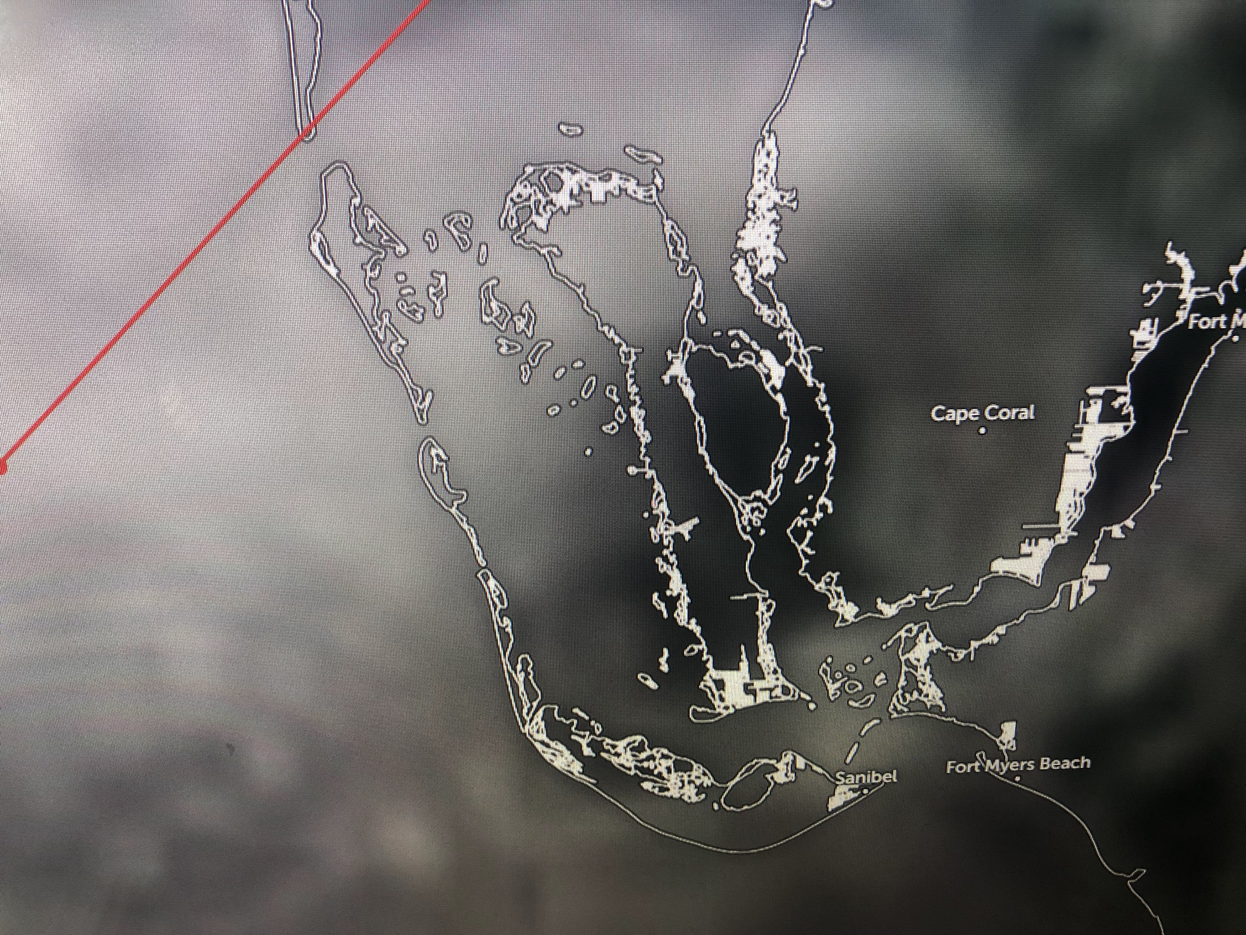

There's Cape Coral again on the right side of the track. I've seen the drone video of the road to Sanibel Island not there no more. It may be weeks before access to Sanibel & Captiva are restored. I'm sure we'll see views looking much like Grand Isla last year after Ida. The storm may be gone, but the rebuilding/restoring process will take months, perhaps years.


So now Tropical Storm Ian is leaving Florida, but he's not done with destroying as NHC makes him a hurricane again later today. The latest track takes the center line into Charleston.


That places Savannah on the weaker side with Myrtle Beach on the stronger side. Charleston is the bullseye with a 4-7' storm surge coming. Hopefully, the local islands have already been evacuated? Ian will be more like a very strong winter-like storm as he interacts with a strong high to the north. He will not be a Hugo (1989), but there will be some impacts. Pay attention if you live along the Carolina coasts.


Locally, we have no issues. Winds are coming down. Nights are comfy cool with days warm, but not hot. next update after 4 PM. Stay tuned!

3 comments:
You are correct as usual Mr. Breck. No one likes to leave but it's better to return safe to an undamaged home. People are spoiled and have unrealistic expectations. Some of the blame is unfortunately on some of the agencies who tend to occasionally overpromise and a lot is the media who seem to overreact much too often. Calm and rational are the order of the day when it's storm season. If you live on the Gulf coast you better learn the drill.
Mandatory evacuation also triggers coverage for evacuation expenses under many homeowner policies. Mayor Cantrell did not implement a mandatory evacuation in advance of Hurricane Ida, leaving homeowners stuck with paying those expsnes.
Cantrell? If a frog was the mayor of N O, it would be a tremendous improvement.
Post a Comment