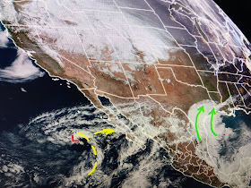
Clouds will overspread us after midnight and Saturday will see way more clouds with only some sunny breaks. The upper disturbance west of the Baja will approach on Sunday and that will be the trigger for widespread rainfall across all of south LA/MS.
The main storm track remains over the northern states with another surge of Arctic air moving towards the Great Lakes. The super cold air will not drop down to us. In fact, we warm up ahead of the late Sunday cold front.
The bottom graphic still shows dew points very low even down in south Texas. That will rapidly change tomorrow and by the afternoon you'll notice a different feel to the air.
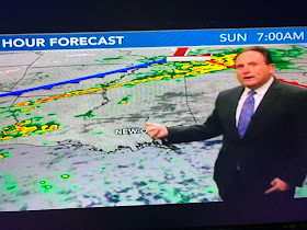
Bruce Katz laid out the time line for when the rain will arrive on Sunday. The morning hours look mainly dry while the afternoon & evening look wet.
Speaking of Brucie...
The little fella ventured over to Drago's (great gumbo!) to have lunch with Bruce and congratulate his promotion to Chief Meteorologist. What most of you might not know about Bruce is that he really is a very nice guy. I'll be with him again this summer as the FOX 8 hurricane consultant assisting if the big one comes again. FOX 8 continues to be Your Weather Authority. Stay tuned!


No comments:
Post a Comment