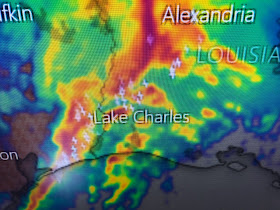
There is a line of strong storms now entering western Louisiana with a history of producing tornadoes & wind damage in eastern Texas.
We have seen winds gusting to 40+ at MSY and we are under a High Wind Warning for this evening.
Models show the highest winds coming with the front so we need to pay attention between 8-11 PM
What's causing all this bad weather? There is a potent upper low NW of Dallas with a strong sub-tropical jet stream along the northern Gulf. Where these two flow split (Green circle), there is upper divergence that causes enhanced surface lifting. In addition, we have contrasting air masses with warm air to the south and cold air to the north.
This is a fast moving system and will be well east of us by daybreak. Much colder air follows with sunshine for the rest of this week. Another system arrives for this weekend.
Finally, where it was cold enough north of Dallas, there was snow!
It melted on the streets of Edmond, OK, but my Grandson (Ethan) seemed to enjoy being out in it. To be a kid again! Stay alert this evening and stay tuned!


No comments:
Post a Comment