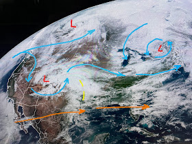
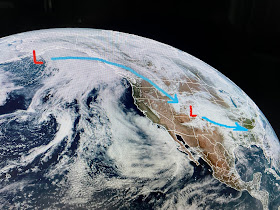
There is a well defined upper low over eastern Canada with another back in western Colorado. In between we have several minor disturbances streaking across in the southern flow. Behind the Colorado low is yet another strong storm in the Gulf of Alaska. So let's time them out.
Tomorrow should be mostly dry here, but more humid as winds turn more off the Gulf. The storms to our north now will track above us while a new severe threat develops across Texas. SPC has placed the bullseye (Level 3 risk) for severe storms right over Dallas/Austin.
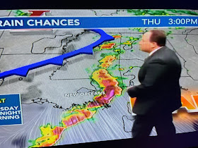
The cold front currently across Colorado will surge our way, but it won't reach here until midday on Thursday as Bruce showed at 5 PM. The "bow echo" feature Thursday PM might suggest the potential form strong, damaging winds for both sides of the Lake. That front should plow eastward making for a dry Friday into midday on Saturday. That's where things get complicated.
First off, the highs the next 4 days will not all be 82. I see Friday as the warmest (mid 80s) along with much of Saturday. The uncertainty is the timing of the upper systems. In a perfect world, Thursday's front clears us out for Friday. Saturday's rains/storms don't arrive until after 5 PM and all the rain is gone by daybreak on Sunday. Bt we all know..."stuff happens!" For gardeners, there will be rain opportunities coming. For Jazz Fest geeks, the driest days should be Friday & Sunday. You just know, the forecast will change as we get closer to the weekend. Stay tuned!


No comments:
Post a Comment