From the remains of Arlene (top view), look out into the Tropical Atlantic & Caribbean, South of 20 degrees (yellow line), there is very little happening. North of that are many areas of low pressure, none of which are expected to develop. The other big issue farther north is huge smoke plumes from wild fires over eastern Canada. (orange arrows)
There are 3 separate smoke plumes moving westward from Buffalo, Detroit to Milwaukee/Chicago. The cold front diving down from northern Canada should help clean out all the bad air.
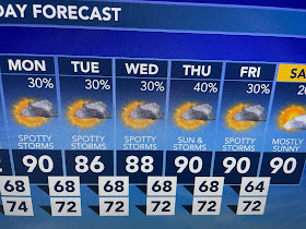
The surface weather pattern has gone boring with the main driver of storms being daytime heating & weak upper lows. We're June hot, but dew points are not like late July & August. If you're lucky to get under a shower, you receive some brief cooling.
About the only thing that changes each day will be the location of PM T-Storms. It will stay hot until October so I promise not to whine every day. Stay tuned!


No comments:
Post a Comment