In my experience, for us to top 95, we need the center of the upper high to be near or over us. Today, it's centered over Mexico extending into Texas. Note San Antonio & Dallas are 96. That center is expected to slowly build to the NE later this week into next week so get use to the heat.
The upper pattern is slowly changing as the deep East coast low lifted to the NE followed by another low that is making for a wet & chilly day over the Great Lakes. 40s & 50s in mid June calls for sweaters & jackets.
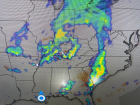
There's a swirl in the clouds across Ohio & Indiana with the low level swirl on radar over Kentucky. But all that action is staying far north of LA/MS.
We still could see a late PM or early evening Storm, but coverage today is at best 20%.
Computer models have a cluster of storms arriving for Monday PM, although I don't see any disturbance coming to increase our chances. Just remember, with 92-95 degree heat, any storms that do bubble up can be strong with lots of lightning, Until the Tropics start to get active, all we have are the daily heat & spotty storms. Stay tuned!


No comments:
Post a Comment