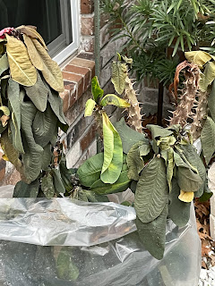
Gone are my variegated ginger which I lose every year. The large, beautiful begonia in the white pot is still alive, but will need some serious pruning. The in ground plants (bottom pic) did fairly well except for the vincas/periwinkles. They're toast and I'll need to yank them out. As my friend Pete Perino often told me after a freeze, leave the plants alone and wait for the new growth to appear. That way you don't over prune and cut off parts of the plant still alive. Even the plants in my He-Shed took a beating.
They look awful, but I know with warmer weather & the longer days, they'll spring back. The potted flowers look great, but Bubba?
It's obvious Bubba will have to be severely cut back. He started as a 6" Crown of Thornes and grew to over 5 feet tall. I'm not giving up on him yet. So why has the warmer air returned?
The dreaded Polar Vortex has lifted back to the Pole with an upper trough reforming over the Rockies. That cuts off the frigid air from Canada giving us an upper flow from the Southwest. Rotating around the upper trough will be several disturbances bringing a heavy rain threat to most of the Southeast. it starts over north Louisiana tomorrow.
That threat will shift over us on Thursday & Friday, perhaps into early Saturday. The bottom graphic is the WPC 5 day rainfall total with the bullseye centered over Louisiana. Amounts could top 5-10" as Bruce pointed out a "training effect" could develop. Here's the model timing.
Tuesday looks to be mostly dry before we get into a wetter stretch Wednesday into Saturday. Your can see the clouds and rain on satellite and radar views.
Following the first disturbance (which is lifting to our north & west) is another in California & Arizona that arrives here for Wednesday & Thursday. So we have no freeze threat this week, but a heavy rain threat.
Finally, let's remember the recent freeze has cooled water temperatures into the 40s. With the return flow off the Gulf, dew points will surge back above 60+ and that means dense sea fog. Brisk winds should keep the fog/low clouds up off the ground, but be cautious if you have to go over roadways over water.. Oh, my fishing trip was cancelled due to cold water temps. I'll be around this week. Stay tuned!


No comments:
Post a Comment