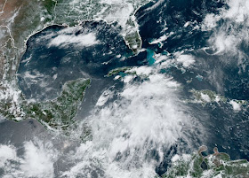
We see this every year when computer models start showing tropical development. The media ramp up the hype despite 1) there is nothing there (to track) yet and 2) it is 10+ days before it reaches the Gulf, IF it ever reaches the Gulf. I get concerned once a "trackable storm" gets far enough west in longitude to where any turn to the north will get it into the Gulf. RIGHT NOW, no one can say with any skill IF soon to be named Beryl will be our concern. So let's get to the Tropics. The African "wave train" has begun early (usually late July thru September) and with above normal/average water temps and lower upper wind shear, that should allow for tropical development.
I've circled the areas NHC is following. Let's begin out in the Atlantic.
I don't think NHC will name this swirl (white arrow) until we start to see those deeper reds around it like back over Africa. Note there is another swirl to the SE of 95 L. Could we be tracking multiple systems soon? My gut tells me NHC might make Invest 95 L a Tropical Depression first, waiting for it to get closer to land (where Recon flights can reach it) before making it Beryl. It's so far out, yet many see the models and get nervous.
C'mon Gang, it's way too soon for "FIRST ANXIETY" ! Look where the GFS & Euro take soon to be Beryl. On top is the GFS.
It takes Beryl on a track similar to Alberto on July 8th while the Euro (bottom) takes it into the Yucatan on July 6th. Should we watch this over the next 10-14 days? Absolutely! But that's all we need to do. I'll let you know when to get nervous. Closer to home in the Caribbean we have Invest 94 L. Could that become Beryl first?
Just like Invest 95 L, 94 L lacks any organized clusters of storms. It will move across Belize & the Yucatan on Friday bringing some gusty winds & heavy squalls. Locally, we are seeing an upper swirl drop southward out of Mississippi. This brought us some welcomed over night rainfall with the boundary now down offshore.
Unfortunately, the front stalled well to our north, but the early clouds & rain did make this morning feel almost nice. Go up to Chicago & they have the sweaters out!
Those early clouds and showers are long gone and temps have bounced back into the 90s where they'll stay for the next 3 months.
If the upper low in Mississippi sinks over us, Friday could see T-Storm activity slightly more widespread. Otherwise, it's a basic summertime weekend. If you missed my poll yesterday, you can still go take it and let me know whether you want to see a Bob Breck podcast during this hurricane season. Stay tuned!


No comments:
Post a Comment