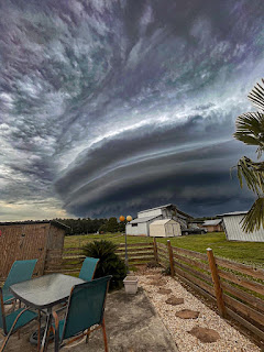
This was a classical "shelf cloud" that often has very strong straight line winds behind it. Luckily, damage was considered minor and no one got hurt.. The current pattern has an upper ridge over the west with a general trough over the east.
It's not exactly a heat dome yet, but the western states will keep getting hotter the longer this pattern continues. And continue it will.
In fact, the GFS model is forecasting a deep eastern trough that will bring a weak cool front through us for next week. Today's GFS has just the hint of a weak low over Florida.
NHC is not interested in talking about tropical development so let's focus on local. It appears the last in a string of upper disturbances is moving through this afternoon.
The weak cold front is not expected to reach us, but it could be close enough to trigger more storms on Thursday. With our dew points in the 70s, there is plenty of moisture for pop up storms during daytime heating.
Radar is showing most of the rain will stay to our north during the next few hours.
So we may see rain chances go down here over the weekend and that means highs will heat up. Later next week, IF the eastern trough is deep enough, we could see another weak front move through for next week. That would block any tropical moisture from coming our way and, if an Alberto-like system is going to from, it would be off the eastern coast of Florida and no threat to us. Stay tuned!


No comments:
Post a Comment