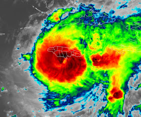
Two things I always looked at when following hurricanes besides direction & forward speed were 1) satellite structure and 2 ) pressure tendency. Often the pressure moves up or down before the winds respond. That appears to be the case with Hurricane Beryl, still a strong Cat. 4 as she brushes the south side of Jamaica. Let's compare satellite views day to day with yesterday on top followed by today's view.
The eye today is no longer distinct like yesterday, but it still looks very symmetrical. It has weakened, but it remains strong & dangerous. Kudos to NHC for being spot on with yesterday's future track.(top graphic)
The middle & bottom views are the current location verifying very well with the forecast.. Beryl's eyewall has made landfall across the southern side of Jamaica, but their biggest city (Kingston) stayed outside the eyewall with peak gusts to 81 mph. Hopefully that limited the damages & any injuries?
So of course, everyone wants to know if the future track ever impacts the LA/MS coasts. Just based on the spaghetti plots, models say no with most models focusing in on Mexico just south of Brownsville.
Here's the 4 pm update from the NHC. They are keeping her sustained winds at 140 mph despite the pressure rising up to 959 mb. It was below 938 mb when she was a Cat. 5.
Without any signs of a turn to the north until Saturday PM, NHC takes the centerline track south of Brownsville. Since the right side of most storms carry the heaviest rainfall, south Texas is in for a soaking. Before that, the Caymans will get hammered tonight with Cancun & Cozumel getting pounded on Friday. Those of you who still fear a turn towards us, let me say again, nothing shows me that can happen since we still have the upper heat dome acting a a block to Beryl. She must keep going to the west.
The surface weather map has little changes, but locally we did see more clouds & storms.
The downpours resulted in some street flooding with my house getting 4.21". The biggest benefit was cooling relief from the heat.
So besides watching Beryl streak towards the Yucatan, expect more heat & more spotty storms as we are deep into summer.
Enjoy tomorrow's holiday and stay tuned!


.jpg)

No comments:
Post a Comment