I was happy to see the NHC's T.W.O. decrease from 50% to 40% this morning and remain there this afternoon. The set up this week is entirely different from Helene's last week. Recall, ALL models were developing a well defined circulation in the Caribbean and moving it into the eastern Gulf. I've already mentioned how accurate models were with Helene. This week, NONE of the models are developing a well defined system and let me try to explain why. We begin with the Water Vapor that has strong SW upper shear over the Gulf and there is an upper low moving westward over the Caribbean. Both are creating a hostile environment for development.
NHC has highlighted a large area for possible development, but not during the next 2-3 days if ever. The X at the bottom of the graphic is where NHC believes some spin could start. Nothing is there yet.
In addition, look at what Helene did to the Oceanic Heat Content over the eastern Gulf. The Northern Gulf is already cooling, but you can see Helene's shadow off Florida's west coast. IF something were to start forming, there's plenty of warm water over the Caribbean, but the Gulf is not as warm as just a few weeks ago. Those things are in our favor.
There is a leftover frontal boundary across the central Gulf, but until the old circulation from leftover Helene to our NE lifts out, that boundary will only slowly shift back over us. My Beach Trip is on and I have until Wednesday PM to decide what to do. Remember, us "old folks" don't sit out in the sun anymore. (4 squamous cell cancers so far!) We go to the beach for the sound of the waves, the smell of the air, the sitting under umbrellas (with sunscreen) sipping our medications! I'll keep updating those of you traveling there with me. For now, I'm excited to see cold fronts coming.
The front coming down over the Plains is not going to bring us sweater weather, but it should be enough to turn any tropical disturbance away to our east this weekend into next week. Temperatures do fall from the 80s into the 50s & 60s behind this front, but a much stronger front will come down after Oct. 15th. It's got me reaching out to "The Lady" to find out whether she's available around Oct. 20th. So far, we have seen 4 landfalling Hurricanes in the northern Gulf. That track pattern may be changing to back over the Atlantic?
All those storms out there will not come our way now that fronts are coming. We'll keep an eye on closer to home areas like the western Caribbean & Gulf. You can see that drop off in names last year.
Hope we see the same drop off this year as we get deeper into October.
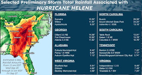
As we leave September, total rainfall of 17.37" at MSY makes this the 2nd wettest September going back to 1946. Only Sept. 1998 at 18.98" was wetter. Finally, there were several asking why Helene was worse in the Carolinas than along the landfalling Florida coast?
The videos have been stunning and depressing, but look why the flooding was so much worse. North Florida had up to a foot of rain while some locations in N.C. topped 30" !!! Plus their terrain is mountainous vs. Florida being mainly flat. Beginning tomorrow, you can get another dose of the Breckster.
"The Southern Charm Of Bob Breck". Really?!!! Stay tuned!


No comments:
Post a Comment