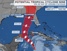
Data from the Recon aircraft indicates that PTC # 9 still does NOT have a well defined center so NHC is not upgrading it on their 4 PM advisory. Satellite loops clearly show this disturbance is getting better organized and the newest NHC information says this will become a major hurricane over the eastern Gulf before landfall on Thursday.
If you're looking at the wide track, it's hard to see much difference from the earlier NHC advisory. However, after further review, if you focus in tight on the centerline track, there has been a notable shift back to the west. The top view is the 10 AM advisory with the bottom picture being the 4 PM.
Earlier the track was east of Tallahassee and now it's just to their west. Is this a trend? Or a temporary flip-flop? Destin is now on the western side of the cone, while Tampa is just outside. Since we still don't have a well defined center to track, everybody from us to south Florida should be paying attention until the storm gets better organized.
On the color infrared view, the T-Storms are not as spread out with the darkest reds showing up just east of the center. We should have an initialization point/center later tonight and that will give me more confidence in the future model solutions. RIGHT NOW, the spaghetti plots focus on the Florida Panhandle east of the beaches. But will they continue to shift farther to the west?
That slight westward shift has taken the heaviest rainfall just off Florida's west coast. Wave heights are increasing where a center is trying to form, so we should have Tropical Storm Helene later tonight or on Tuesday. So what will steer Helene?
They is an upper ridge across Florida shifting to the east as an strong upper low over the Dakotas is diving our way. Look at what the GFS does with that low beginning with that diving trough in the top graphic valid for Wednesday AM.
IF the GFS forecast proves correct, then this westward shift in the track should not continue as the upper low cuts off and drops over western Louisiana. That should create a sling shot effect with Helene picking her up over the eastern Gulf and accelerating her northward towards the Big Ben area of Florida. But until we have a center, let's not buy into model solutions as "gospel" or written in stone. What I do know is the circulation of Helene should bring us a cold front later this week.
It will not be sweater weather, but it will be less humid and a good feel.
So what to watch for? Once we have a center to track, we want it to make the turn to the north as soon as possible. What I don't want to see is the center track farther to the west towards the tip of the Yucatan. RIGHT NOW, I'm not nervous for us, but have some concerns for the Florida beaches IF the westward shift continues. I'm also concerned for my friends in Tampa since these track shifts usually go back to the right. Bottom line? More watching and waiting. Stay tuned!


No comments:
Post a Comment