Over my 50 years of tracking tropical weather, lots has changed, mainly technology. Where we once might have one model that was restricted from public view, now we get many model runs that anyone can follow every six hours. What I have learned is computer models don't do well with final landfall location BEFORE something actually forms. Yet I'm seeing so many posts talking doom & gloom when there still is NOTHING THERE YET. As Bruce said, we need to chill out.
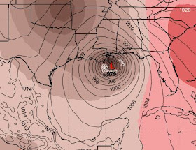
NHC keeps elevating the probabilities for development based on computer models telling them something is coming to the Gulf late NEXT week. But models are all over the place. We begin with the Euro AI for next Friday.
Yikes, that gets my attention! However, I always would say, "I want to be the bullseye at 5 days out". Why? Because we know the storm will go either to the right (east) or left (west) of that position. Look at the model differences beginning with the GFS for next Friday.
The GFS takes whatever forms towards Florida's West Coast on Saturday. But look at the Euro.
Geez, it forms something weaker farther to the west over the southern Gulf and keeps it there for Sunday morning Sept. 29th. So who do we believe? How about NONE OF THE ABOVE! Let's wait for something to develop before we start accepting model solutions. What should you be doing tomorrow & Saturday? How about checking your supplies that you used during Francine and hit the stores to restock this weekend. IF you wait until next week, panic buying sets in. No panic this weekend. there is no immediate tropical threat anywhere.
With this last weekend of summer, we also see no fronts in sight. Look at the near 100 degree heat over Texas!


.jpg)
.jpg)
No comments:
Post a Comment