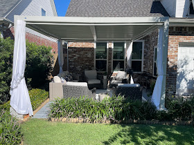
I told you I would show you some before and after pictures of my plants/yard, and here they are. The top shows the before with the bottom after. The differences are not dramatic, but notice more of the white vincas before vs after.
Basically, my yard escaped with the curtains on my pergola being the only casualty.
As you can see, I'm back in business. As I sat rocking in my chair sipping my chardonnay last night, I wondered how long before the animals returned? I have two bird feeders that attract many varieties of birds and bees & butterflies are constantly swarming around my many flowers. Where do they go during the storm? (Shelter in place!) We'll keep wondering, but know it didn't take them long to return. Once I put my feeders back, the birds were on them within the hour. But look at the Butterflies!
Yes, that is a Monarch butterfly and it made me feel happy my friends were back. It reminded me of one of Brenda's paintings.
She calls it "God's confetti" and it's more than a painting. It's a 3D 16 X 40 layered original acrylic on canvas individually drawn & painted butterflies. Stunning & very life-like. If you're interested in seeing more of Brenda's art, go to https://www.brendabreck.com.
That lingering swirl of Francine is expected to slowly sink to the SE over this weekend with some of her energy trying to form another low off the Carolina coasts. NHC is highlighting that area.
IF it develops, it will be named Helene. What? What happened to the "G" name?
While we were dealing with Francine, a system way, way out in the Atlantic formed. It is now Tropical Storm Gordon and is expected to just be a fish storm. Forget about it. No model develops anything in the Gulf or Caribbean during the next 7-10 days. That almost gets us to October.
If you're looking for a real cool front, not happening for awhile. We're not as hot as August, but it's still plenty warm. Finally, we all have seen the goofy wobbles of the ill-defined eye of Francine.
Today's Advocate had a story that I thought showed the importance of the centerline. The dotted black line was the NHC official track coming close to Baton Rouge. That late shift meant our Capital city did NOT receive the impacts predicted getting far less wind & rain. Avoid the eyewall, stay left of the centerline should mean very few issues. However, be on the right(east) side of the track places you in the way more powerful side of the storm. Flooding on both sides of the Lake caused major problems.


These are pictures of Margaret Dubuisson's yard where the Abita River overflowed the banks. Her husband (David Blitch) says the river level reached the second highest in memory, and that goes back a long time when the late James Blitch was the owner! Needless to say, we don't want anymore rain for awhile. Unfortunately, as the upper energy with Francine rotates around her this weekend & that might trigger some afternoon storms. Best to all who are suffering and try to enjoy your weekend. Stay tuned!


.jpg)


No comments:
Post a Comment