You all know how much I hate the cold as I grew up outside Chicago (Hammond, Indiana) and experienced what minus 25 below zero real temperature feels like. However, our hottest September ever is beginning to wear on me. Worse yet, recent model runs now indicate we may have to wait until we're well into October before REAL relief arrives. That could mean we will have to keep watching the tropics way longer than we have in the past? Until fronts start coming, we will have the chance for a late season storm threatening us. I don't see anything on the immediate horizon, but there is an area south of Puerto Rico that looks troubling.
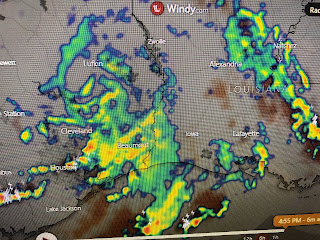
Tropical Storm Jerry is farther out in the Atlantic and early forecasts keep the track turning to the north well U.S. NHC only gives the system south of Puerto Rico a 10% chance for development, but remember it's September. The remains of Imelda continue to dump on western Louisiana & SE Texas with the center now SW of Lufkin. She is drifting slowly to the north which should keep most of her precipitation to our west. Humberto is starting to weaken, but he is battering Bermuda with strong winds & waves. The Tropics are likely to stay active for the next 2-3 weeks. Stay tuned!


No comments:
Post a Comment