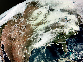
SPC is thinking another round of severe storms will break out for today and Wednesday.
Interesting to see today's storms are not in the bullseye (best chances) for severe storms. I do believe the northern developing line will enter the bullseye later this afternoon, but what happens to the cluster of storms nearer us? If they hold together, we could see some showers after dark. SPC is expecting them to fade after the sun goes down.
You can see the upper energy with the swirl over the Dakotas that will rapidly plunge our way overnight. This should trigger a squall line of storms arriving here after daybreak Wednesday. The ingredients are there for strong storms as we are back in the warm air sector with surging dew points (low level moisture) ahead of our next cold front.
Notice 70+ dew points already over Texas. Let's keep up with the weather tonight and early Wednesday and make sure you're all set up with the FOX 8 Weather App in case warnings are issued.
The batch of storms currently to our west has lots of lightning with them and I expect tomorrow's storms to be similar. Some good news today is the Corps of Engineers will have all bays of the Spillway closed by Friday. I read the comments and I share the same feelings regarding the repeated openings. Let's hope the rains let up and the River keeps falling.
I close with a view of a strong storm east of Cape Cod with a trailing cold front back down over the Bahamas. As we approach another Hurricane season, early storms often form along the trailing end of cold fronts. Geez, I'm not ready for anymore stress. The virus is enough for this year! Stay home, stay healthy & stay tuned!


No comments:
Post a Comment