I was reading the NWS discussion from this morning where they are already raising flags regarding the increase potential for heavy rains in Texas and Louisiana. They say..."environment looks like it could be primed for some heavy rain. It would not be a surprise to see Flash Flood Watches at some point next week." Why you ask?
This picture is the GFS model for Wednesday at mid day showing a "cut off low" (translation, slow mover) near Dallas. In addition, it looks like the upper pattern has an "Omega block" setting up with 2 lows with a high in-between. Bottom line, we'll be on the wet side of that system which is still way out over the Rockies. Closer to home...
Clusters of T-Storms are forming from the Yucatan Channel/SE Gulf/NW Caribbean to south Florida. The Euro model hints at some slight development by Monday and Tuesday of next week bringing heavy rains to south Florida. Right now, that system shouldn't affect us.
Today we have basic summertime boomers bubbling up during daytime heating. That pattern should last through next Tuesday as we have no fronts around.
Temperature-wise, it's almost basic summertime except under the upper low over the Rockies. That will be our system to watch with the POSSIBILITY of some heavy rains here for Wednesday & Thursday...if the low stalls and cuts off. We have plenty of time to watch it.
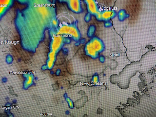
Finally, this picture is a classic view of the sea breeze front pushing inland from the Gulf. Storms fire off inland while the beaches are sunny & hot. Oh I did see where the GFS has a hurricane in the central Gulf in 14 days. The Euro does not. Need I say more? Stay tuned!


No comments:
Post a Comment