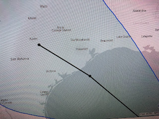
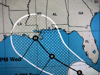
As I await the 10 PM update, satellite loops continue to indicate 2 struggling tropical disturbances. Tropical Storm Laura actually looks more ragged than TD 14.
With Laura, I actually see multiple little lows. Without Recon data, I have no clue how NHC can pick out a well defined center to track. TD 14 has a burst of storms near the center of curculation and I'm curious to see if it's upgraded at 10 PM. The wild card to me is the lingering upper low over the Gulf that is producing lots of wind shear and dry air,
OK the new info is in and NHC has upgraded TD 14 to Tropical Storm Marco. They keep their center line forecast track the same, but now do not make it hurricane strength once over the Gulf.
If you look at the previous 4 PM tack and the latest at 10 PM, they are identical. As long as Marco follows the center line track or even goes farther to the left (west) of it, our impacts should be minimal. If it would go farther to the right (east) of the center line, then parts of SE LA, especially coastal, would feel some impacts. I still feel Marco is more of a problem for Texas than us. Despite what the satellite views show, NHC continues to indicate Laura will be our concern next week.
The center line forecast track continues the westward trend as at 4 PM it was at the mouth of the River while tonight's update moves it to Port Fourchon. That does not make me feel any better since we would be on the stronger side with the greater impacts. here's the questions that will need to be answered over the next several days. The current track takes it right over Puerto Rico and the biggest mountains (10,000 ft+) of Hispaniola and then over Cuba. That interaction with land might just tear it apart leaving just a wave as it reaches the Gulf on Monday. However, by then the upper low with wind shear will be gone and Laura could rapidly regroup as it moves over the warmest waters of the Loop Current. Am I nervous yet? Let's say I'm getting concerned as I do not like the track of Laura. She still could stay far enough south of our coast and go farther to the west to keep the worst winds and rains away from us. I would not bank on that. Tomorrow I'll detail what we'll need to do IF it becomes more apparent that Laura is coming here. Next update in the Morning. Stay tuned!


10 comments:
Thanks Bob.... will check back in the morning...Good Night & God Bless
Thank you Bob!
Thank you Bob! You are the best!
Thank you
You are today's Nash. Thank you.
Glad to still have you getting us through these storms Bob, keep up the good work my friend!
Thank you Bob. As usual this Calif Girl is on edge thus time of year. But atleast we dont have Forest fires, and Quakes!
T h a n k. Y o u,
Bob
You are my go-to guy every hurricane season. Thank you Bob!
Thank you Bob. Your perspective really helps cut through all the hype!
Post a Comment