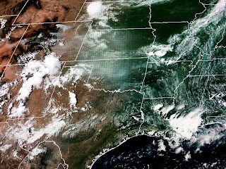
Normally we have a summer pattern where the air rotates around the Bermuda High with wind flow moving across Louisiana from the SE to NW. This August we have an unusual upper pattern that has an East Coast trough bringing storms down from the NW to SE. The axis of the Bermuda High has been suppressed far to our south over the Gulf. Why am I pointing this out? Because look at where the smoke from some large fires in Colorado is heading.
That smoke could produce some colorful sunrises/sets during the next several days. That's if our current cloud cover thins out.
This afternoon's boomers have had plenty of electrical activity and the heavy rains have brought welcomed coolness. To our west outside the rain, they're baking in the mid 90s. I still see our rain chances decreasing after tomorrow and I'll be watching to see if the drier air over the central plains can stagger down to us. Mid August and the Gulf & Caribbean are quiet. Stay tuned!


No comments:
Post a Comment