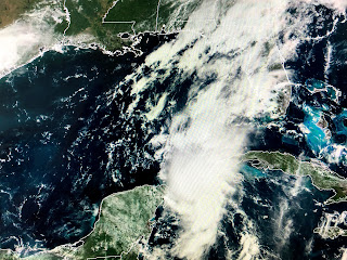
My blog allows me to continue to post MY thoughts and not just repeat what the NHC discussion says. So I;m throwing out the idea that Louisiana & Mississippi could actually see impacts from 2 hurricanes next week, I've already told you I felt "concerned" about Laura since I expect her to be the stronger storm, and that Marco would be a problem for Texas. However, I'm becoming more "concerned" about Marco giving us some impacts before Laura arrives. Let me show you why.
Clearly we have two systems that are getting better organized based on satellite views. Let's look at Marco first. There has been a burst of T-Storms around the center that Recon relocated much farther to the east of the previous position. I still see a more northerly track, and if that continues, it means it'll take the right (east) side of the cone instead of down the center line giving us a much greater threat for impacts. Again, the wild card appears to be the upper trough over the western Gulf that won't allow Marco to turn west yet.
That could bring the center very close to Grand Isle/Pt. Fourchon during the day on Monday placing SE LA/MS on the wet/stronger side of Marco. NHC believes he will become a hurricane this afternoon and that appears to be confirmed by the radar out of Cuba showing an eye feature. NHC also believes Marco will weaken as it approaches the coast due to increasing SW wind shear. Expect watches or warnings to be issued on NHC's 4 PM advisory. Looking at Laura...
She has obviously gotten better organized since last night, however, she has land with high mountains to contend with for the next 2-3 days that should prevent any rapid strengthening.
The NHC intensity forecast keeps her a tropical storm until she reaches the Gulf, but quickly ramps her up to a hurricane by Tuesday morning. They have shifted the forecast track another 20 miles to the west and I would personally like that to continue for us. IF Laura's center/eye can stay far enough south and to the west, then the brunt of her impacts would miss us. She could easily become a Cat. 2 or 3 Hurricane so we still have much to get nervous about even IF the westward trending track continues. Our weather will begin to go down hill on Monday followed by a brief break before Laura arrives on Wednesday. I trust many of you are taking this opportunity to get supplies before people start to "freak out" next week. My next post will be after 4 PM. Stay tuned!


14 comments:
Bob’s the Best
You are the best! Scary times. Can you believe your seeing this happen!
I look at the NHC and then your blog every day. Thank you for all you do!!!
I look at the NHC and then your blog every day. Thank you for all you do!!!
Thank you Bob!!!
Tanya,
Lafitte
Just 48 hours ago you said the opposite that you weren’t “concerned” .... flip flop
This isn't politics, and to modify the forecast because of updated information isn't a flip flop, it's just the nature of meteorology! Be glad there is someone continually studying the data and bringing us 40+ years of experience, training, and wisdom with no network or station agenda or bias.
Thank You Bob. You are the only Forecast that I listen to.
Thank you Bob for still looking out for us. Be safe.
Thank you for continuing to inform us with your experience and expertise!
> Just 48 hours ago you said the opposite that you weren’t “concerned” .... flip flop
Wow. You really don't have the faintest understanding of how weather actually works, do you? You know we're dealing with one of the most unpredictable things on the planet, right? You're attacking a trained, respected expert about something you don't know anything about -- so congratulations, you're right in the spirit of 2020.
Thanks Bob! I worry about my daughter and grand babies in Nola... I appreciate you!
K.....
Texas
Literally all he does is take little cheap shots at the NHC and other networks as he lays out every possible outcome and then toots his horn and claims victory when on finally matches what he posted days prior. Just 24 hrs ago he said Marco was a problem for Texas and then said he does understand why the big shift East...
Bob has very little training with Hurricanes.. hence his prediction Marco was going to be a Texas event not Louisiana and now he questions the NHC motive behind big shift East . Maybe he should take some steering current training on low and high pressure ?
Post a Comment