Tropical Storm Beta's center has been relocated farther to the north and its max. winds are now up to 60 mph in a large cluster of storms on its northern side. Beta still has a fast forward motion of NNE at 12 mph and I find the newest NHC track a little hard to believe.
Recon aircraft found Beta's pressure had fallen quite a bit and that resulted in increasing its max. winds by 20 mph. There are SW upper shearing winds blowing all T-Storms to the NE side of Beta and I wonder if some of those storms will push onto the Louisiana coast by daybreak. Remember Marco's track turned to the left but all of his impacts went to the NE. This has been a confusing hurricane season lately with only Laura being well behaved. I'm sorry to say we'll be dealing with another slow, erratically moving storm for the next 3-5+ days. My biggest concern is the heavy rain potential IF Beta's tries to get closer to us. Look at the rain total forecast for the next 7 days.
Any northward shift brings some significant totals into Louisiana. What will force Beta to make the 90 degree turn to the west? There is a large surface high centered over Wisconsin with a cool front pushed off shore into the northern Gulf. that should temporary act as the block forcing Beta towards Texas. However, we'll be on the "wet side" of this system and if the turn doesn't happen soon, I think we could see some of the outer bands/squalls along the coast at daybreak. The farther north you go, the less chance for rain this weekend.
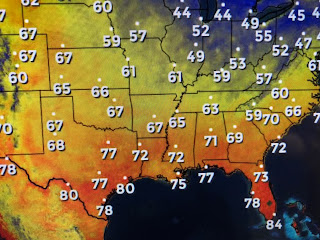
Look at the lower dew points (drier air) that have sweep southward across Texas with houston & Brownsville in the 50s! Tropical systems do not like ( don't strengthen) cooler and drier air. Things to watch on Saturday will be our surface wind direction and speed.
Right now they are NNE at 10-20 mph. I expect them to become more easterly IF Beta makes the turn to the west. Notice what a difference in wave heights (1-2')with a wind blowing off the coast as opposed to last week's SE winds (15-20'). Let's just hope this air mass from the north will tamper development of Tropical Storm beta. I'll update again in the morning. Stay tuned!


10 comments:
Don’t just say you find the NHC newest track hard to believe, give us YOUR expert track..
Thanks Mr. Breck, your blog keeps me sane. You are appreciated....
It seems the nhc is wanting to give the storms names just to make their predictions accurate. Meanwhile they are confusing people and trying to insight panic. Thanks Bob for adding a little sanity and levity to the weather. These new younger forecasters need to get off their computers and rely more on common sense. I make better predictions then they do with all their computers.
Thanks again Bob....you make sure we are not going insane with all of these storms...keep us posted....we appreciate your opinion!
He won't do that. He has no idea.his entire career has been nothing more than reporting the NHC predictions. When they get it right, he gets it right
Bob Breck is a weather reporter, NOT a forcaster
Duh...
So glad I found you blog!! I lost trust on the weather channel after their tall and bold hurricane expert left after Katrina.
I said it in the past, but worth repeating. When Gustave was in the gulf it looked really bad for New Orleans. Bob came on TV and said guys if it passes over this particular spot in the gulf which I think it will, there is a huge sandbar that will make it loose strength. That's exactly what happened. I will bring my plants in when he does!
Thank you for your continuously updated blog & insights into storm reports.
Much appreciated and has helped allay stress during hurricane season!
Post a Comment