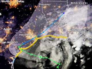
The top pic was from midday when Beta had a burst of storms around the center while the bottom is near current. There has been a total collapse in all T-Storms around the center so obviously you knew NHC would not strengthen it on their 10 PM advisory. Forward motion remains WNW at 6 mph which is slow but still way faster than Sally's 2-3 mph. There latest track is unchanged taking beta inland near Victoria, almost stalling before moving slowly to the NE.
Normally, that would not be good for us as that center line track keeps us on the wet side. However, the environment around Beta is far different than when Sally was here. A cold front has pushed well down into the Gulf bringing a huge slug of cooler and drier air.
Look at those dew points in the 40s & 50s to our north. In addition, surface pressures are RISING all around us. look at the hourly report showing northing but Rs next to the pressure.
That tells me the surface high continues to build in. I mentioned this in previous posts about how Hurricane Teddy's movement up off the East coast would block the high from moving into the Atlantic. In fact, his circulation would bring the center of the high into the Carolinas.
What I believe that will do is push Beta farther to the west into Texas and maybe even dissipate her to a weak low by Wednesday. NHC is not calling for that as they are following the computer models. Look what the dry air is doing to the rain that has tried to move northward along our coast.
While most of the squalls around Beta have diminished, so has the area to our south off the mouth of the river.
In fact, the brightest cluster of storms is over Florida with a weak area of low pressure. NHC gives that disturbance a ZERO chance to develop.
Finally, all the guidance still calls for the POTENTIAL for heavy rainfall during the next 3-5 day all along the northern Gulf coast. My gut tells me that is not likely IF surface high pressure continues to build in from the NE. Oh we could see some rainfall IF Beta makes the move back to the NE later this week. I just think the cooler & drier air will take its toll on this tropical system. Our main issues tonight are the gusty winds driving high water into areas outside the Levee protection system. Could Beta have another burst of storms around it tonight? Sure, but I'm thinking the squalls/storms off our coast will stay there, at least for the next 2 days. We'll give it another look tomorrow morning. Stay tuned!


5 comments:
Thank you !
Thank you for the information. I have to be in NOLA Thursday.
Thanks Bob
thanks Bob.
Thank you so much Bob. I check your blog 3 times a day for your wisdom and expertise. Whether good news or bad I feel like Im getting the best report anywhere. Miss you on WVUE but David is following well in your footsteps.
Post a Comment