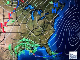
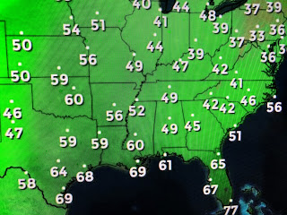
This will be a true test to the accuracy of the models as you can see almost all stall it and then radically change direction to the NE. Here's my take on what we should be looking for. IF this increase in forward motion continues through landfall, then I believe the center of Beta could move farther inland and get its circulation away from the Gulf. That would be what we want as once over land, wind speeds will decrease (already down to barely 50 mph) and perhaps the rainfall potential will decrease too.
IF the rainfall forecast proves correct (I don't think it will), areas just to the west of NOLA could receive 5-10" during the next 5-7 days with the city proper 3-5". Let me go over the meteorology I see as to why I feel that is too high.
The top pic shows the Water Vapor having drier air wrapping all around Beta separating it from the storms off our coast. The question then is, will the band of moisture off our coast hang together and move inland over us?
That could happen, but I go back to all the drier air that has been brought down from the north enhanced by the circulation around Hurricane Teddy moving up the East coast.
Dew points in the 40s are almost down to northern Florida and I believe this cooler and drier airmass will keep any rainfall we do receive from becoming excessive. Our main issue is all the high water being forced into SE LA. by the interaction of Beta with the strong surface high.
You can see winds are 15-25 with gust to near 40, but also see that none of the pressure reports have the barometer falling indicating the high is holding while Beta drifts farther away. The wind direction is more easterly now and that has tides & seas way up with flooding outside the levees.
Our high water won't come down until Beta gets inland and the winds die down. that is not likely to happen before Wednesday at the soonest.
So let's pay attention to see if that faster motion continues and the rand band off our coast remains offshore. Oh, NHC is still watching something over Florida. This warm loving fella can't wait for the October cold air! Next update after 4 PM. Stay tuned!


3 comments:
Bob, any chance of the remnant south of us becoming a TS?
Thanks for the updates. After reading all of your updates I now feel well informed. Thanks
You said you found their track for Beta “unbelievable” ... it’s been following pretty close. Why did you feel their track was “unbelievable” explain why they have been correct.
Post a Comment