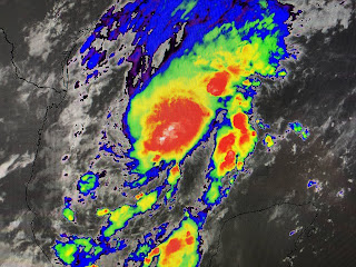
This front is bringing out the sweaters & jackets up north and we'll notice a definite different feels to the air Tomorrow. NHC has not upgraded TD 22 to Tropical Storm Wilfred yet since the Recon Aircraft that was supposed to be in the storm now had engine issues and returned to Keesler AFB. My guess is they'll name it soon since the satellite views have a burst of storms near the center.
This disturbance is down over the warm Gulf waters now and should get stronger. However, once the cooler and drier air starts working into the system over the weekend, it should weaken as the NHC track indicates.
The bottom 2 graphics are the Euro for Tuesday morning now bringing soon to be Wilfred to the coast SW of Houston and then inland to the TX/LA border on Wednesday as a depression. So this should not be a wind storm like Sally, but more a heavy rain threat. Look at the rainfall prediction for the next 7 days.
There is a bulls eye of 10-20+" over the Gulf. Depending on the track inland, some places are going to have flooding issues. it's too soon to know if that'll include us.
Some rain is already approaching our coast, but the drier air moving southward should limit the northward movement today and tomorrow. Bottom line, we monitor as always a tropical system in the Gulf. The difference this time is we have the cooler and drier air moving in that SHOULD not allow the rapid development into a strong hurricane like Laura & Sally. Next update later today. Stay tuned!


10 comments:
Fox 8 app just announced: "2020 hurricane season runs out of names, going Greek now." I wouldn't be surprised if Jim Cantore is doing backward somersaults somewhere.
Looks like Bob was wrong again calling this storm wilfred since yesterday.
Unknown Comic - you apparently have nothing to do and all day to do it.
Thank you Bob!
So what I read from your analysis, Bob is that the cooler driver air SHOULD prevent this from being a strong hurricane, but maybe it won't. That is very smart of you to protect yourself either way
There is still a chance it could develop into a strong hurricane but the models and consensus is that it will not. If I roll a 6-sided dice the odds are it won't land on the #1, but if I said it couldn't happen that would be a lie. Same situation here for this storm. Go find someone else to troll.
Bob loves to criticize other meteorologists but can’t take that the heat himself. Appears he deleted all the comments about his fear mongering by making reference to a model bring a major storm to us next week.
So Bob is just rolling the dice with his predictions. Tell us Bob. What is your gut feeling on this storm? Is it our storm or not? Or do you need to wait 6 hours before landfall to make that prediction?
Is there any chance the storm can go straight up to NOLA
I'm beginning to think all you peeps need something to do OR are all of you the same person with too much time on your hands and nothing better to do than argue with yourself on somebody's blog!
Post a Comment