From what I'm seeing on satellite and radar, the actual surface track could be like Marco a few weeks ago. Remember that storm followed the NHC's track BUT all the IMPACTS went away from the center to the NE into Florida. That's what I'm seeing with Sally. Look at the Satellite pics.
It's obvious Sally's inner core is becoming better organized and Recon found lower pressure, which often means higher winds. For now they kept her winds at 65 mph, but I expect that to increase later today. The surface center is on the left side of where I have the arrow. I like to use land based radars once a storm gets close to the coast.
It's pretty easy to follow the center's motion and, RIGHT NOW , to me it looks like the center is heading towards the MS/AL state line. IF that track proves to be reality, we here in SE LA. will see very little from Sally aside from high tides/storm surge. IF it goes farther to the east of Biloxi, then those of you along the Mississippi Gulf coast will be spared the brunt of the storm. The worst now appears to focus on Mobile Bay eastward to the AL/FL line.
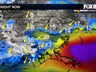
Note our winds are NNE which tells mean Sally's center is going well to our east. According to the latest Recon report, Sally's surface wind field of tropical storm force only goes 20-25 miles on the western side while it extends over 100+ miles on the eastern and northern sides. I repeat, IF the latest NHC track forecast proves correct, All of SE LA will see very little impact from Tropical Storm Sally. RIGHT NOW, the impacts are staying to the north and east of the surface center and that places areas EAST of Gulfport under the gun for the heavy rains (10-20"+). Any farther shift in the track to the east would be good for Biloxi/Ocean Springs. If I see something change, I will do a special update after 1 PM. For now, relax, take a deep breath, and start to pray for our friends to the east. Stay tuned!


11 comments:
NAVGEM still has this thing going right over New Orleans, and they did a great job with the last two storms around 48 hours out. My question is, if we cannot nail the center, how can they predict its path? Where you have your mouse at on the above pictures is where I agree the center is. They NHC does not agree with that and jogged it back and east. This is just very confusing.
I really like the image you are using that shows the cone with the center line (like the one you reference that is showing Biloxi as the landfall.). Where can we see find that version online to look at? Thanks for all your helpful information, explanation and analysis.
Thank you Bob! You have a large following on the MS Gulf Coast and we appreciate your updates.
It is looking better for us here in South Plaquemines Parish. Thank you Bob.
I will always follow your advice on the weather. You have always given the us the most accurate information! Thank you!
I wish it will just go inland and get over it. I am sick and tried of all the back and forth . Right now I really don't give a Shit where it goes. It can go to Hell for as i care right Now.
Since we are getting nne winds too does that mean east of Gulfport as of now?
This is going to be very close for NOLA, Bay St. Louis looks like a good bet right now
Thank you so much for these updates, you are the only forecaster that I trust and listen to.
Thank you for all you do and being a live a board your wealth of information is priceless. We are from Texas and your devout followers turned us on to you, you are much loved. Only suggestion I have is I wish you had a tip jar so I could buy you around of golf. I know this is your hobby now but it's so hopefully to so many. Thanks again!
Thanks Bob, You're retired and yet you are still very much at the forefront of technology with the Fox news staff. If you could pass along a comment I so appreciate David, Shelby, Zack and Bruce. Wonderful meteorologists and they provide very good insight and amazing graphics.Excellent speakers. Kudos to the graphics dept. You are the man and I faithfully read all your blogs and depend on them. Be safe
Post a Comment