Here you come again, just when I've begun to get myself together, you waltz right in the door.
just like you've done before...and shakin' me up so that all I really know is here you come again,
and here I go.
Before I review Sally, we have another disturbance in the SW Gulf that several computer models develop and bring it northward to Louisiana this weekend!!! NHC has highlighted this area for days and Zack and David mentioned it yesterday, so it's not like where did that come from?
You can clearly see the low level circulation (arrow) and this system will be in a race for the last name on the 2020 Hurricane name list (Wilfred) with the disturbance coming off of Africa. The system has been designated Invest 90L and early model runs hint at the movement to us.
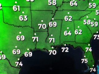
The Euro (which was very wrong with Sally) brings perhaps a Tropical Storm to our Coast early on Sunday around Morgan City. I am not the one to start raising the panic flag, but we really don't need this 3rd named storm within a months time. I was hoping on a weak cold front to follow Sally, but that doesn't appear likely as the drier air remains far to our north. these are the dew points.
Another concern is the black dashed line that identifies a surface trough of low pressure extending down to 90L. The surface high that blocked Sally's northward movement for 2 days is now off the east coast, so as Sally leaves, there is nothing remaining that would keep 90L away. This early in the game is too soon to speculate when 90L could just as easily move westward into Mexico. I just want you to be aware that we do have "something" out there that could mean "here you come again!" Now on to Sally.
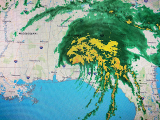
Early on, the computer models had little trouble with Sally. Only when she reached the latitude of Tampa did she start to misbehave as she ran out of steering. First she slowed down, then her center reformed farther to the east, then she crawled to the west, then she stalled and began moving to the north, then to the NE making landfall at Gulf Shores, Alabama around daybreak with a last minute strengthening before landfall. The greatest surge (10'+) and rainfall (30"+) were to the east of the center line track.
The videos of the damages have been very impressive, but sad. IF you have reservations for the beaches this weekend, please check with your condo/hotel to see if they are even open. Power is out in most locations and my gut tells me they don't need any more visitors during the clean up. Locally, winds and seas are slowly going down.
It does appear the buoy south of Mobile and east of the mouth of the River is gone or damaged. Let's be thankful that Sally didn't come here.I'm looking for our 1st real cold front, but I don't see it for the next 7-10 days. I still see lots of smoke streaming across the United States. Only 3 1/2 months left until 2021! Unless I have something new on the SW Gulf disturbance, I won't post again until tomorrow PM. Stay tuned!


6 comments:
This has been an exhausting Hurricane Season. Just doesn't feel "natural".Very surreal. I'm over it.
I've been watching this disturbance in the Gulf it looked like it kept going further south why won't it keep going that way
Thank you Bob for continuing to post about updates on this never-ending hurricane season. I truly enjoy reading your posts even though I don't like the subject of them. You are appreciated��
Because the jet stream dips down starting Thurs and will pull it toward the northwest then kinda leaves and Invest 90L begins to meander along the coast of Louisiana and drifts back toward the TX/LA state line AGAIN!
Bob said "just 3 and a half months til 2021". There's no promise 2021 will be better but I sure pray it will, as I am sure all of you do too.
Bette
Thank you Bob. You are the only one I am listening to:)
Post a Comment