there has been another burst of T-Storms around her center, but the lack of an apparent eye tells me Sally may have stopped getting stronger. Radar views clearly identify a center of rotation, but the Gawd Darn thing just isn't moving.
The northern rain bands have moved inland over the Florida beaches, but the western edge has NOT spread towards Louisiana. So what will the new 10 PM track do? The newest model runs continue the earlier trend of moving the track farther to the east away from us and I would expect NHC will nudge their center line closer to Mobile.
On the surface map, there is a large high centered over Michigan that will pull to the east coast. Without any upper steering, Sally maybe waiting for the surface high to move out before heading northward tomorrow. Let's see the new 10 PM NHC track.
As expected, the new center line track is shifted farther to the east now moving inland east of the MS/AL state line and then over Mobile. This is great news for Mississippi from Biloxi westward. Also, the Hurricane Warning is lowered from Grand Isle westward. As I mentioned on the last several posts, IF the NHC's center line track proves correct, SE LA/NOLA will see very little impacts except for high tides/surge outside the levees. Her forward motion is only 3 mph or basically stationary. She still has 100 mph winds near the center which makes her a Cat. 2.
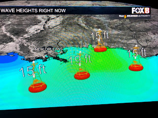
In addition, wave heights haven't increase telling me Sally has weakened a little. Our local wind directions remain NNE and that means Sally has not moved towards us on a track different from the NHC's. If you have been watching David showing the VIPIR storm surge graphic tonight, you could see the higher surge numbers have pushed well to our east. All in all, I'm still feeling relaxed and will go to sleep knowing there will be no significant changes coming over night. I have not closed my hurricane shutters nor moved my plants and lawn furniture. We still look good Gang, but there is that 5% chance that something strange could happen. We'll be back with an update around 8 AM. Stay tuned!


14 comments:
You’re a true angel Bobert.
Still waiting to see if my mom is gonna make that lasagna for ya.
Crossing my fingers she does.
Thanks coach! Bless up! Go Saints!
Hey also!
I’m having a daughter in November?
What do you think I should name her?
I was thinking Bob. But people keep saying that’s only a boy name.
Let me know!
Will be waiting for your response
Bless up Bob!
You should name her Brecka
There is always "Roberta"...
Bobbie would be cute for a girl!
Or just Breck
Well i'm a girl and my name is kent and my girl dog is pete. I vote naming the young lady "bob"
I feel like naming my child Weirdo would only set her up for a life of bullying and name calling.
But I will consider it. Thanks for the options.
Bless Up
Go Saints
All hail Bob
Incredible. I hope the real Bob thinks the same.
Y’all like lasagna?
I could try and see if my mom’d make enough for us all.
I’ll let y’all kno
It is 140 am tuesday morn just seen update has dropped to 90 bm still same 3mph but now moving back due west ?
It is 140 am tuesday morn just seen update has dropped to 90 bm still same 3mph but now moving back due west ?
Wondering when someone is going to talk about it moving west.....
Thank you Bob Breck.
4 a.m. wnw @2 winds @ 85
Post a Comment