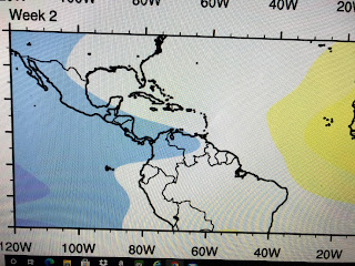
These 3 graphics show the MJO today followed by the next 2 weeks. Sally was last week so you'll have to imagine a shift farther to the west of the MJO's bullseye. The top graphic has the center of the sinking air out over the Tropical Atlantic extending westward into the Caribbean. Note the Gulf is barely in that phase so I assume when Sally was over the northern Gulf, the center of the sinking air was too far to the south & east. While there has been lots of activity these past 2 weeks, nothing has happened in the Caribbean & Wilfred quickly died out in the Atlantic. In fact, the tracks of all those storms coming off of Africa have been turning to the north going around the center of sinking air. For the next 2 weeks, that center keeps shifting farther over the MDR (Main Development Region) so I'll be surprised to see any more systems form coming off of Africa. We go into the neutral phase during the next 2 weeks, so if we see any development it will have to be much closer to home (Gulf, Western Caribbean)
Note how the recent tracks have all curved back to the north avoiding the center of sinking air. The season of long track storms coming off of Africa is over for us based on what I'm seeing with the MJO. I am not ready to call in The Fat Lady to sing just yet since I'd like to see several real cold fronts come down here as we get into October. Once beyond the 10th I'll feel more relaxed. Back to our Gulf Storm...Beta was down graded to a Tropical Depression at 10 AM. The forward motion to the NE has begun, but the pace is only 2 mph. A band of heavy squalls keeps rotating in over Galveston & Houston, but the heavy squalls sitting off our coast appear separated from Beta's circulation. The main factors in Beta's lack of development were upper SW wind shear and cooler and drier air surrounding it.
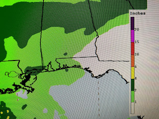
Note the colder (reds & yellows) cloud tops are along our coast, but most of that rain should stay there for today. I do expect that band will begin moving on shore tonight & Wednesday, but current rain forecasts have most of us seeing less than 2". The big picture remains the same.
Hurricane Teddy's circulation has driven a cold front well down past Florida into Cuba. Not only is this a dry airmass (note all the 40,50 & 60s dew points), but it is a record setting cold airmass. As Teddy finally pulls out and the surface high begins to drift off the East Coast, we should see TD Beta start to pick up forward speed to the NE by tomorrow. That frontal boundary down in the Gulf should start to move back toward Florida and NHC has a slight (10%) chance for development there.
It's just something to watch, but it won't be our problem. As Beta weakens, our winds and seas are slowly decreasing.
However, our high water levels outside the levees will fall painfully slowly until we can get the wind direction back out of the west. That won't happen until what's left of Beta staggers past us to our north and east late Thursday into Friday. Better, brighter days are coming Gang as this has been a long, dreary stretch of ugly weather. Next update after 4 PM. Oh, did I mention we are now no longer in Summer? Stay tuned!


1 comment:
Tropical storm paulette come back to life?
Post a Comment