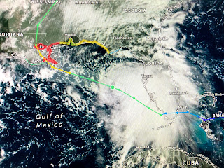
The timing of arrival appears to be moved up slightly changing the beginning of impacts from after midnight Monday through late afternoon on Tuesday. RIGHT NOW, there are no indications Sally will stall. She will slow down as she approaches our coast and then accelerate away on Wednesday. Here are the differences in the center line track forecast.
The top 2 graphics are from 4 AM while the bottom 2 are the 10 AM advisory. It's not a great shift to the west, but it's an important shift since it will 1) place all of SE LA. in the eye wall (greatest winds & surge) and 2) all of SE LA & MS will be on the strong side of the storm. The line from Morgan City to Baton Rouge will see far less impacts if this track proves correct. There still is time for the track to shift back to the east like in did in Lake Charles sparing them the greatest surge. But RIGHT NOW it sure looks like we'll all have enough winds to cause widespread power outages at the very least.
The other big concern then becomes heavy rainfall and the final track position will make a big difference for some. If you live in Mississippi or Alabama, you won't dodge the heavy rains with 10-15+" likely. Your can see in Louisiana how the track will make a big difference even from one side of the Parish to the other, like in St. Tammany. This is currently a right side loaded storms.
The arrow shows where the center is with all the storms on the south and east sides. The west coast of Florida is receiving the heavy rainfall this morning, but they're only have 15-25 mph winds. NHC does believe the current wind shear making Sally lop-sided will diminish and that is why they predict future strengthening. However, recent models are not as bullish on making it a Cat. 2 and that is why they keeps it a Cat. 1 at landfall. In addition, the latest pressure from the Recon plane has gone UP signaling Sally is not intensifying yet.
Winds and seas are increasing and it will be important to watch wind direction this afternoon and on Monday. Any shift to the SE or S means Sally is going farther to our west. IF the direction stays ENE or becomes more NE to N, that would tell me Sally's center will pass to our east. The current surge forecast of 7-11 feet is way less than Katrina's 25-30 feet+. Our new levees should be able to handle this surge unless there's a breech. But the 4-6'+ in lake Pontchartrain will easily mean water up over the seawalls on BOTH sides of the Lake. The South Shore have levees to protect the city where the North Shore does not.
So what should we be doing today and tomorrow? IF you choose to stay, you must have the usual supplies to last 4-7 days PLUS window protection PLUS emergency power. IF the track doesn't change, there will be widespread power outages that could last days to a week. It's still Summer and the heat without AC will be brutal. Gas up you car, gets some cash from the bank and charge up cell phones. Once cable goes out, the only way to keep up with the storm will be on the FOX 8 Weather App.
I have functional hurricane shutters which I will close either this afternoon or tomorrow morning. I have a full house generator so I will have AC. With Covid-19, I cannot accept any visitors! If you don't have the above and don't want to endure the issues caused by no power, I would suggest heading to relatives IF they live farther to the west. RIGHT NOW, Baton Rouge will have way less impacts than SE LA/MS. To avoid traffic gridlock, I'd leave after the Saints game this afternoon or early on Monday. As I mentioned on my last post, I AM NERVOUS regarding this current track shift to the west. Once NHC and their models get locked in, it's unlikely there will be any major changes. We will NOT dodge some impacts from Sally, and that includes the MS/AL coasts. Will update after the 4 PM update from NHC. Stay tuned!


6 comments:
The models, for now, appear to not be quite locked in to a particular track.
That is the worst place to have your generator. Never have it near a window or door or vent. CARBON MONOXIDE. EVEN IF YOU HAVE YOUR SHUTTERS DOWN.
Thank you
Thank you, Bob, I really appreciate you explaining the wind directions. Presently the facts honestly as you see them, makes me feel informed.
Hey Bospower, that's not a gasoline generator... and whoever installed it and tied it into the natural gas lines sure as hell knew where to put it.
I would point out that DURING the game would be the best time to get on the roads without too much traffic.
Post a Comment