


So IF the new NHC track proves correct, what can we expect? Widespread tree damage and power outages. The above photos are my son's house in Edmond, OK where the damage was caused by an ice storm yesterday. Same results there, extensive power outages. I will go finish preparing my yard after this post by moving some of my potted plants into my "He Shed" and will put some of the others next to my house. My patio furniture is heavy metal, but I'll pull that next to the house too.


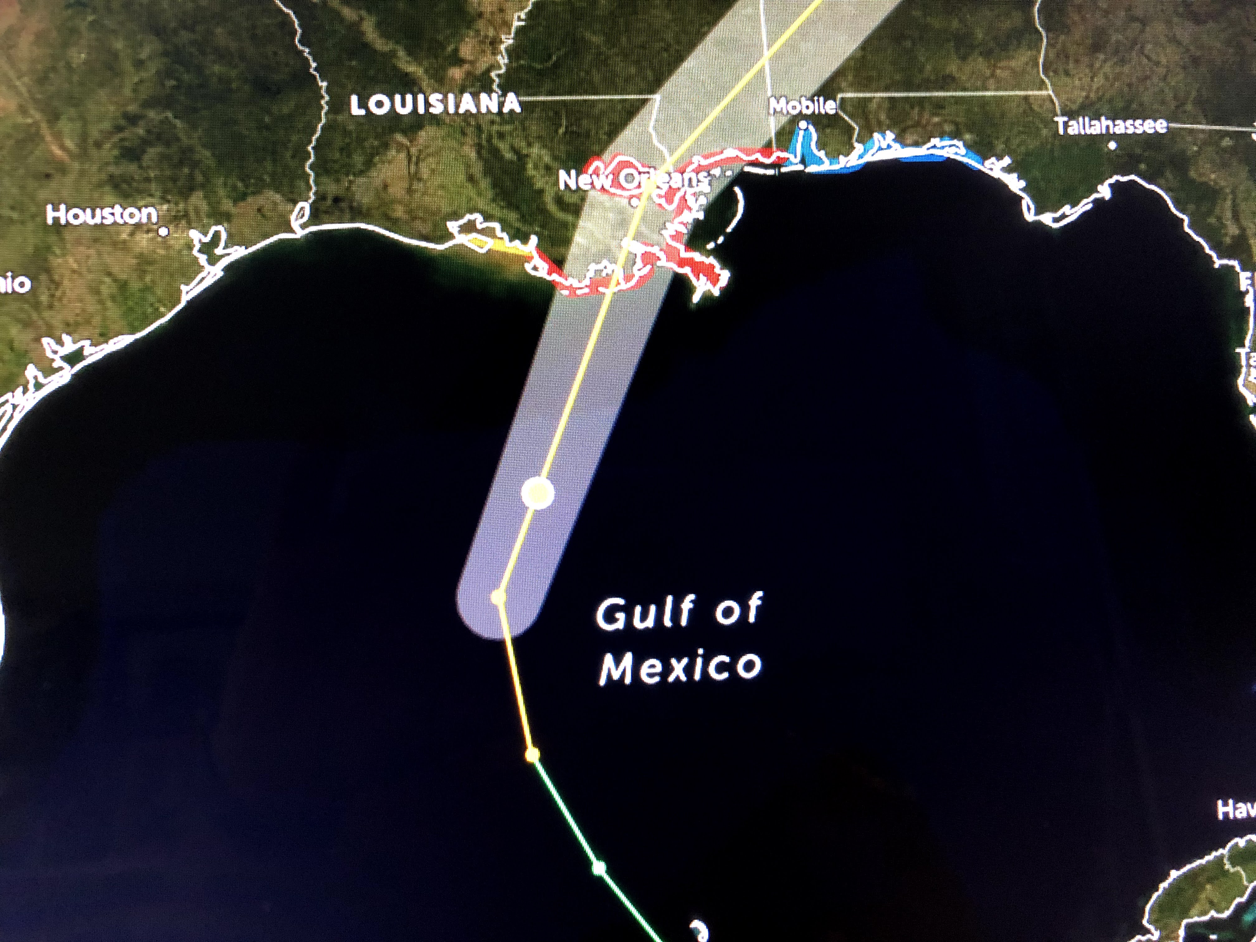
Right now this is a very symmetrical storm. As it heads farther to the north and into increasing upper wind shear, I would expect it to become more "right side loaded". For the life of me, I don't know why NHC shifted the track back to the west. They obviously have information I don't know about as I still feel Zeta will turn more to the NE ( currently NNE 010 degrees) taking the track nearer their previous tracks farther to our east.


On the other hand, there is a frontal boundary to our west & north and maybe Zeta is being drawn to that? Look at how chilly it is in Houston. We will need sweaters and jackets tomorrow. Unfortunately the cold air will not get here soon enough to deflect Zeta away. So here's what I want you to watch during the next 3-6 hours.


On www.bobbreck.com, look at the wind direction. IF our winds continue to remain out of the SE, then Zeta is going to track over us or even to our west putting us into the stronger side of the storm. However, IF our wind direction begins to turn to the east or even NE, then Zeta will probably go to our east. It will make a bug difference on impacts. I'll be posting at both 1 PM and again after 4 PM. Right now I'm off to move my plants and then get ready to HUNKER DOWN GANG. Nobody should be on the streets after 4 PM. Stay tuned!

20 comments:
Bob, is there any way to protect what’s planted in the ground? I’m gonna loose my hibiscus tree
I feel excitement in the air. Nothing excites me more than the fury of Mother Nature!
Hurricane lover
Will you be putting up your shutters?
I appreciate your level-headed commentary in the face of otherwise sensational coverage.
It’s lose, not loose!
Hurricane lover
I grew up in Norman, just south of Edmond. My friends there have been sending me all sorts of pics of the sad frozen trees. It seems crazy that we are about to have a hurricane here when my friends not that far north of us are having an ice storm. 2020, what a year. As always, thank you Bob.
Your hibiscus tree is going to be blown into next week:/
Thanks for the update Bob. And for anonymous, you are ignorant.
Don't you guys have anything else to go troll. Try politics, that's a blast right now.
Are you OK, buddy? Everything alright at home? I know trolling the weather blog of a 73 year old retired meteorologist is the only way you can feel alive right now, but I promise things will get better soon. Remember it's always darkest before the dawn, sport. You got this.
Thanks Bob your filtering of all the other static is much appreciated, watch the wind, got it. Be safe all.
To this particular anonymous:
"I feel excitement in the air. Nothing excites me more than the fury of Mother Nature! Hurricane lover.
Your a fool, if you really have a death wish try joining one of our fine military services, lots of ways to get killed (oh i'm a 23 yr USAF vet retired 01/01/01, I know).
I don’t know what you’re talking about! I have nothing but respect for Bob Breck. I’m here because I love hurricanes and tropical weather. If you don’t like hurricanes, that’s your problem, not mine!
Hurricane lover
The tree will probably live unless something falls on it.
I've been living here 45 years and if the wind don't blow it over, it should be fine.
The most recent radar loop shows Zeta’s eye following the eastern edge of the cone, not the center track.
Bob how could this become a car.2 even though you and rest of weather experts believe it would be a minimal TS at worse when it made landfall?
Looks like Cantore is in the wrong place just like he was for the last one
Mike in Thibodaux It very much does look like that it's making a sharp turn already toward Plaquemines
That guy is always on Bobs blog I think he was or is a meteorologist that feels played that Bob gets all the attention and he dont
God is showing us who's boss!!
Bette
Post a Comment