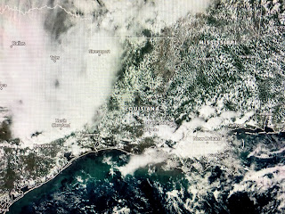
I mention this because NHC has designated an area in the NW Caribbean as Invest 95L. Yesterday they highlighted an area to the NE taking whatever forms east of Florida & the Gulf. Today they have flip-flopped and now have that area into the southern Gulf. Should we feel nervous?
I'm not even though several model tracks head towards the northern Gulf coast. Look at the middle graphic that was taken 3 week ago with Meteorologist Zack Fradella showing the Ocean Heat Content or Energy Potential of the Gulf and Caribbean. Notice how the bottom pic has most of the Gulf much cooler. I suspect 95L being over the warmest waters on the Planet will become our next named storm (Zeta). However, the farther north it goes, the cooler the waters and the stronger the wind shear. In addition, several cold fronts are coming that will protect us from any major issues.
It's really chilly behind this front, but it won't roar through us since it lacks upper air support and will likely stall just to our south. Still, this is the coldest outbreak so far this season.
that should at least get us into the drier air behind the front as dew points are back into the 70s here, but fall into the 40s at Dallas. Ahead of this front, showers & T-Storms have erupted bringing most of SE LA. much welcomed rainfall.
Along with the rain has been a lot of lightning. Most of these showers should be gone before daybreak.
While from the Gulf up to the Great Lakes are getting soaked, most of the West remains dry. Only Washington has rain falling. A close up view of today's smoke plumes appear to show the fires are in eastern Nevada. Some help is coming for the northern Rockies in the form of heavy snows. We need to see the storm track shift farther to the south to include California, Nevada & Utah in on the precipitation. Probably won't update until tomorrow or if NHC makes 95L a TD, whatever comes sooner. Stay tuned!


5 comments:
Just when I thought I was out, they pull me back in! Godfather, Part III
Alphonce P
Bucktown, USA
no more hurricanes, but that ice storm will come on Dec.17th!
I don't even watch the news anymore. I just checkout you blog. Thanks Bob.
LL
thanx Bob!
"It won't be a problem for the Gulf." Bob Breck 11/22
So now it will be but just not a "major" problem...
Post a Comment