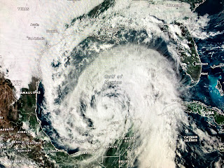
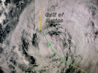
Looking at the 4 PM center line track would indicate very little change from the 10 AM forecast. However, when you look at the tight graphics, there has been a slight shift back to the west.
The top graphic is from 10 AM with the bottom from 4 PM. You can see the earlier forecast had the center line passing east of Gulfport while the new one has it just to the west. That is not a good trend for SE LA. The farther to the west that track goes, the greater impacts we'll see. Regardless, we will see some impacts, but the stronger side of the storm will be to the east of NOLA.
That's confirmed by the above graphics. The tropical storm force wind field is focused on Plaquemines Parish and then to the MS/AL coasts. The highest storm surge will be east of the Mississippi River with the greatest from Bay St. Louis eastward.
Satellite views all afternoon showed a well defined circulation , but no T-Storms around the center. During the past 2 hours there has been a burst on the south side of the storm. I'm still wondering what all the cold air to the NW of Zeta will have on Zeta's development?
My hope is that Zeta starts to draw in to the western side that colder and drier air preventing the storm from developing. That won't happen until Zeta gets north of 25 degrees tomorrow morning. So far I have not done any precautions since I'll have time in the morning on Wednesday. I do not plan on closing my hurricane shutters. Let's watch what that track does later tonight and tomorrow morning. We want it to shift back to the east so we remain on the weaker side of Zeta. As a reminder, this is not August & September and Zeta will not have the wind & surge impacts that Laura & Sally had. The greatest impacts will be from Grand Isle across Plaquemines Parish on over to the Mississippi coast from Bay St. Louis eastward. Zeta will not linger and we'll only have 6-8 hours of heavy rainfall (2-4"+) and gusty winds. Power outages will probably the biggest impact for SE LA. I'll post again after the 10 PM NHC advisory. Stay tuned!


19 comments:
Bob are you only posting on FB? I'm not getting my emails anymore. I tried to subscribe to email again today, but it said I'm already subscribed. Thanks.
Bob, I folded my hand and put up my lexan shutters over my picture window, or as they say in Bucktown, "Pitcher window." Thanks Bob.
Alphonse Pecounce
Bucktown, USA
Thanks for the update Bob....
looking like 60mph on the south shore and 55 mph on the north shore. shifting a bit back west likely strong tropical storm upon landfall. Good luck and enjoy the weekend as it should be beautiful.
Are you moving in your plants, Bob?
Fat Lady sang, don't worrying going east over Florida, not a Gulf problem, pressure will protect us .... yadda yadda yadda.. well you are INCORRECT (again)
You dont have much of a life do you......sittin around trolling Bob’s blogs to gripe about it. If you think he’s so bad at it, watch someone else. You must feel a need to out other people down to make yourself feel better. Get a life, some friends, or a hobby.
Be quiet, Margaret Orr!
Thanks Bob. I'll worry if you bring your plants in.
Thanks Bob!
OK now what is going on here? Thought Bob said hurricane for us were pretty much over last month? Now since he said that we have had two!
To the idiots without good understanding. Bob didn't say we would not get anymore storms after the "fat lady" sang. He said that we should be protected from any major hurricanes which is 3,4,or 5. The strongest was a cat 2, so take your keyboard and go play in the street.
Wait. The Trolls' "names" are becoming diverse , aren't they? Smh. Come out, Cindy. We know it's you ��
Thanks for your great analysis Bob. I watch the gang on Fox 8 and then I come check with your blog for the last word. Keep it up!
Check your spam filter. It may be catching the updates.
thanks
Its mt Bob's fault if the Fat Lady wants to do encores! You know how those Chunky Divas are, always wanting to be in the spotlight! I just wish she would come on and sing her finale!
Thank you Bob, you’re much appreciated all these years!!!
You’re family to us !!
Post a Comment