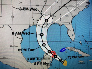
The 4 PM center line track was just to the east of Slidell. Now the latest has it going west of Slidell.
It's not a great shift, but any shift to the west will place many of us on the stronger side of the storm. This will be a fast mover so rainfall totals will not be excessive.
Satellite views indicate the core is trying to get better organized, but it remains a lop sided system with most storms south of the center.
We'll have all day tomorrow to watch what the new model runs show. Zeta won't get into the southern Gulf until Tuesday morning. The question will be how soon will the approaching upper trough turn Zeta to the NE. For us, the sooner the better. Even still, this will be a weakening Tropical Storm and will not have the major impacts of Laura, Delta or Sally.
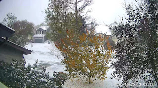
These pictures are from my son's house in Longmont, CO. NE of Boulder. Very cold air is coming to us for later this week. It won't get here soon enough to block Zeta, but hopefully the upper shear will turn the storm away from NOLA? Get ready for a rainy, breezy Wednesday before the chill arrives. Next update after 10 AM tomorrow. Stay tuned!


5 comments:
Thank you!
Thank you Mr Breck. Always appreciate your updates.
Seriously thanks for exactly what? Being wrong? Does anyone actually read the blogs and then compare to the storm outcomes? Big F on grading scale.
Hey Cindy, Try thanking Mr.Breck for the 30+ yrs. Of his life he dedicated to our community.
Thank him for exactly what? Guessing? Guy has been terrible at forecasting tropical systems. Have you not learned anything this year? Amazing stuff.. sheep
Post a Comment