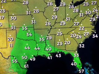
As you can see, there is a nearly 30 degrees spread between the temperature and dew points which means this is really dry, good feeling air. But changes are coming.
As the surface high drifts to the east, a return flow will bring back clouds and low level moisture off the Gulf. Strong south winds will allow highs to surge into the 70s on Wednesday before the big chill arrives on Christmas Eve.
looking up into Canada, the super chill has moderated a little from yesterday, but computer models keep showing a big dip in the upper level winds coming for Christmas.
The top graphic is today's upper flow with the bottom being on Christmas Eve. If correct, that should bring down the Arctic air into the lower 48. The question for us is...How much of that chill comes to us? or does more of it shift towards Florida and the East Coast? Just watched David say the South shore should stay above freezing and I tend to agree. I mentioned yesterday that I'll wait until Wednesday before I bring any of my potted plants into my He-Shed. I have not changed my plans. Stay tuned!


1 comment:
Appreciate the info as always.
Post a Comment