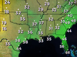
There is a slight warming to our west and Tuesday & Wednesday should be back 60+. This is a very dry airmass with dew points in the 30s, so if you are dressed for it, it feels really nice outside.
There is a weak snow storm over the Northeast, but when you see Denver 50+ with near 50 up into Montana, you know there is no Arctic air over the lower 48. I see several fronts coming this week, but there will be no "Polar Express" to worry about this week.
The NE storm will lay down 2-4"+ snow totals, but this is not a major Nor'Easter. The bottom satellite view shows the snow on the ground left behind from this storm over Iowa. You can clearly see all the rivers pop out.
. Our next rain chance comes on Thursday with the next cold front. We could briefly top 70 on Wednesday before the sweaters and coats return for Friday & the weekend. I know many of you are enjoying these sunny & cool days and so am I. I do hate the cold, but this is not the brutal Winter cold like what happened 51 years ago when we set a record low of 25 degrees. No signs of that nonsense coming...yet! Stay tuned and Go Saints! Saints 30, Panthers 24. Go Bears too!


No comments:
Post a Comment