Today's high only reached 33 making this the coldest daytime Mardi Gras ever. If we didn't have another fast moving disturbance approaching tonight, we'd probably would be worried about dipping as cold as last night (25). But that won't happen as clouds will over spread us after midnight and milder air will stream northward ahead of a surface low off the Texas coast. The upper low is already in New Mexico.
The bottom graphic is valid for Wednesday at noon. You can see there will be another band of heavy snow and ice well north of us and our question becomes...Will we get into the warm air sector? SPC believes we will and indicates a slight risk for severe storms tomorrow evening.
The greater risk should stay down along the coasts and to our east. This will be a fast moving system and rainfall totals should be 1-2" at worst. Colder air will return on the back side so the warm up will be brief and the following cold far less intense.
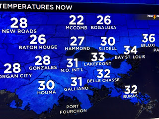
We could be back into the 70s next week and that will feel good. For tonight, we are below freezing and I will check with David at 10 PM to make sure we haven't dipped down to 28. These are the 7 PM temps. If any of you have a frozen pipe, you may not find out until we thaw out tomorrow.
We should be near 40 by daybreak with the coldest coming around midnight tonight. Finally, I saw this on Facebook and I had to chuckle. All of this snow & cold is so unusual to us who live down South.
Now if that doesn't bring a smile to your face, you are hopelessly affected by this bitter cold! Snap out of it. It never lasts long. A warm up is coming! Stay tuned!


No comments:
Post a Comment