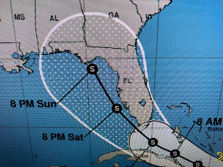
Since Fred will be over land for another 12-18 hours, he's expected to weaken back to a Depression before regains some strength once back over water. Here's the 4 PM track from NHC.
The bottom graphic is the arrival time for tropical storm force winds. Some of you are probably getting nervous seen the cone getting closer to us. That's why I like the center line track to determine NHC's thinking regarding which way is it trending, more east or more west. So let's look back at the last 3 advisories.
The top graphic is from 4 PM yesterday with the middle being from 4 AM this morning while the bottom is the latest. What do you see? Here's what I see. 1) NHC has been very consistent in their track guidance hardly shifting it at all, 2) If there has been a slight shift, the bottom graphic has the center line slightly more to the east (away from us) now heading right up the AL/GA border. Based on that, as I said yesterday, this should be a Florida storm and not impact LA/MS unless there is a drastic shift in track. I don't see that happening. We'll keep watching and waiting, but if you have reservations in Florida this weekend into next week, don't cancel yet since this might not be much of a storm. However, keep paying attention in case Fred decides to get frisky and become stronger once over the eastern Gulf.
The rest of the Gulf has several clusters of storms, but you have to look out into the Atlantic to find our probable next named (Grace) storm. NHC has it on a similar track as Fred, but we have many days to follow it.
The surface weather map has no fronts coming our way and most of the eastern 2/3 of the nation is enduring hot & humid conditions like us. Look at the 70+ dew points up into NYC & Boston. Ugh!
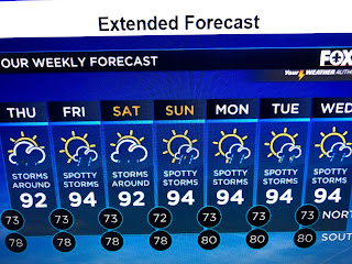
We have seen some cooling relief from showers again today, but highs typically top 90 before the rain arrives. Look for the 7 day to not change until September. And finally...
The level of the Mississippi River at the Carrollton gage has fallen to 4 feet and is expect to reach 3 feet next week. Why is that important? We don't want a high river at this time of the year. If a storm does come with a 10-15' surge backing up the river flow, we have plenty room before any levee would be topped. Just a little good news. Stay tuned!


1 comment:
For a long time, charts from NOAA have shown the statistical peak of hurricane season as being September 10th. Bob, do you see this peak ever being revised to an earlier date based on the number of earlier storms we have been seeing?
Post a Comment