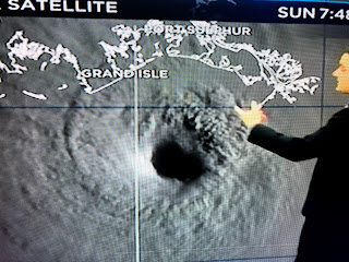
The 4AM center line track hasn't changed since last night, so the eastward shift has stopped. What we need to see during the next 5-10 hours is the center to go slightly west of the NHC forecast so metro NOLA doesn't get clipped by the eyewall winds.
The worst impacts will hit from Grand Isle to Kenner to Hammond westward. Even the heart of the city could see 100+ gusts since Ida has become stronger. Here's the current radar views.
There is a heavy band of rain over the North Shore, but not much south until you reach the coast. Zack Fradella used future radar to show where the eyewall will go.
The far eastern part of the eyewall clips NOLA You can see the cities west of MSY that will feel the brunt of the storm.
The other major change from NHC is a higher storm surge since Ida is stronger. Now the Mississippi coast will see 6-8 feet+ which will probably put wat up on Hwy 90. Grand Isle's surge could be 16'+ with up to 8; in Lake P. Look at the wave heights offshore!
Winds are still rather tame, but they will quickly ramp up after 10 AM. So the table has been set for days. We've known the danger was coming. The predictions have been super accurate. Now it's time to "hunker down" and pray. My blog posts are internet dependent so I might have to switch over to my son (Rob) in Colorado later today when cable goes out. He has set up a link for you to send damage photos , but don't go taking them until AFTER the winds subsides.
photos@bobbreck.com
A final note...landfalling hurricanes often have quick burst tornadoes that give little warning time, if any. When you get into a heavy rain squall, be prepared to be in your "safe room" in case a tornado dips down. Stay safe and my next post will be at 10 AM. Let's keep hoping the eye drifts farther to the west of Port Fourchon keeping the eyewall winds from the city.


8 comments:
Thank you Bob, your forecasts have helped me to prepare and deal with countless storms including Katrina and I will always trust your judgment.
Hi, We stayed and really think we should have left. We are here in Kenner & scared. Please pray for us & I will be continue to pray for everyone’s safety . Bob please tell Brenda hi for me.
Stay safe🙏
Thank you Bob. Its just comforting to know that you're here with us for some reason. Even if not in the same house.
Your still the best Bob. Miss you on the JumboTron at the Dome, buddy!
praying for all of you; this thing came up so very very fast. It is understandable that you stayed, there was not time to make decisions especially if you have kids. Our son left with his wife and one child and 4 cats. But also still making the decision whether they should have left, even tho they are in Ms. We are in Florida and in tandem with you all-having been thru stuff like this. Decisions like this. We said we would never evacuate again-but this storm is a .....
With everything going on in life right now, this may be the final straw. Might be time to become more mobile in the future instead of having a stationary house down here. It’s always a roll of the dice. From a projected cat 2 Thursday night to this monster. Numb and just tired of it all. 5th wheeler and upgraded truck coming soon.
Update us unknown and let us know how you’re doing. Download Zello in case you need emergency assistance and/or have phone service interrupted..it works when low data. There is a channel for the Cajun Navy and New Orleans. Add both and if you need rescue when weather permits they will come.
Post a Comment