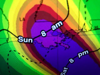
Ida now has an eyewall that should only become more circular during the night until we have the donut look much like Hurricane Zeta last October.
Actually the center line landfall with Ida will be very close to Zeta's above. Here's the latest NHC's track that has shifted slightly (10-15 miles) to the EAST! Recon is reporting a rapid pressure fall which means rapid intensification has begun. I suspect on the next advisory at 7 PM, the winds will increase from 105 (Cat. 2) to 115 (Cat. 3) or higher.
The center line is now over Houma and I hope that trend does not continue as it brings the strongest wind field closer to Metro NOLA. That means Hurricane force gusts will be felt from Metairie westward with locations west of Destrehan/LaPlace getting close to the eyewall winds (100 mph+). Houma/Thibodaux will be hammered with gusts to 120 mph+. That will likely cause weaker buildings to fail and many roofs to fly off. I fear many neighborhoods will be uninhabitable for weeks, possibly months.
The surge in Lake Pontchartrain is now up to 8 feet which would put water into many neighborhoods surrounding the Lake on the North Shore. For the South Shore, the main issues will be power outages and flooding rainfall.
Bottom line, the danger that has been well advertised for Ida is going to happen. RIGHT NOW, the eyewall will stay just to the west of Metairie/Kenner/Lafitte, but not by much. Any further shift to the right (east) will bring the Hurricane's main impacts farther to the east. Nobody should be outside after 9-10 AM on Sunday. We'll have about 10-12 hours of dangerous wind gusts that could kill you if they crash down a tree or bring down power poles. Stay safe and be ready for the power and cable to go out for days. Expect streets, maybe some homes, to flood. You can still leave between now and midnight, but head away from the coast/water. Next post at 10 PM. Stay tuned!


14 comments:
Stay safe Bob! What you think about the impact to Bay St Louis, MS?
What are your predictions for those of us on the MS Gulf Coast?
Bob isn’t 87.5 almost 2 degrees west since this morning. I’m confused about slight jog to East when clearly is West. Please explain.
What are we looking at in Loranger/ Robert area?
Ida's eye has been continually on the east side of the National Hurricane Center's cone all day long as well as on the East side of all models you don't have to take my word for it go on WDSU. Com get on their radar hit satellite scroll down the menu and click on track and click on models and watch the eye ride to the east side of the cone and to the East side of all the models why are y'all not telling us this
Bob, I know you are doing this as a serves to all of us . I think you very much for doing something you really don't have too . Stay safe and God Bless.
Same question, thanks Bob!
Hurricanes don't move in a straight line. They wobble. So the course can stay the same while the eye can move a little without changing course.
Did you stay at your house and do you have a generator?
What can we expect in Westwego ?
Bob,your prayers should be directed to God though Jesus and not Mary. She cannot hear you. Only God hears petitions. Read your Bible.
Well as i predicted it shifted east making landfall in grand isle. Over 12 hour trend is not a wobble
Not a wobble as landfall has shown
Tom, God doesn't give a damn about the impact of these storms; otherwise, they wouldn't occur in the first place. I would like to politely remind you to shut the fuck up regarding another's religious beliefs, although I will openly admit I'm being hypocritical when I say you're all wasting time rubbing those two brain cells together to pin an invisible force out there as giving a damn about our existence.
Go Raiders
Post a Comment