It also has chased the super cold air over Canada back into Alaska & Siberia. The welcomed news is the rains over central and northern California that will work their way southward during the next 2 days. There will be yet another strong storm arriving over the weekend to add to their moisture totals. Perhaps this will put a dent into their multi-year drought?
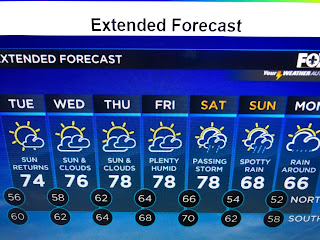
Fortunately, the rest of the U.S. is quiet since the tragic tornado outbreak of last Friday. A cold front has stall off our coast, but it is already washing out/dissipating. Note the 40 dewpoints to our north while we're back to near 60. That Spring feel will be back tomorrow and linger into the weekend when our next front will try to stagger through. It could bring us enough rainfall to elevate us into the number 2 position regarding wettest years.
We don't even need a half inch to move up the ladder. With over half the month to go, that should not be a problem.
Radar is finding a few showers over east Texas, but they are moving northward. The next main weather issue will be the daily dense fog. Satellite views show lots of low clouds along our coast. The clear skies and drier air across the North Shore will be on full retreat as southerly winds return.
Our normal highs should be in the mid 60s, but some nights our lows won't get that cool. Models are hinting for a cooler Christmas week, but nothing drastic. Keep hoping! Stay tuned!


No comments:
Post a Comment