The current upper low north of the Great Lakes is lifting out as another comes sliding out of western Canada.
That upper low on Tuesday stops moving into the U.S and instead pulls eastward towards Hudson Bay. The second graphic is valid for Thursday and it indicates a trough starts to dive down over the Plains. Notice how that trough sharpens and deepens as it moves over us. That will bring the super cold down to the Gulf Coast. The bottom view is valid for Christmas Eve and it suggests a real bomb (Nor'Easter) will explode somewhere along the East Coast. We will get frigid, but the core of the bitter cold will stay just to our north and east. However, look at the forecast lows for Christmas morning.
Temperatures below zero will sag down to Indianapolis to St. Louis over to Kansas City. A close up view has MSY at 29. BIX at 23 and MCB at 19. Burr! Obviously, we'll all have to be ready to use full precautions next weekend. Any snow chances?
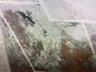
msaybe some sleet/flurries once the front plows through, but it won't last very long. The snow cover forecast (top view) keeps the one inch line from OKC to north of LIT & MEM and then up the East coast. Note, if you're traveling to any of the big cities in the Northeast, it appears they will get mainly rain and NOT have a White Christmas. The view over the Rockies tells a different story. I've outlined the clouds from the snow cover.
They have buku snow on the ground with the ski resorts outside Salt Lake & Park City reporting great conditions. So too in Colorado where west of the Continental Divide the amounts are terrific.
In the short term, we've endured an ugly Saturday with low clouds & some sprinkles along the Gulf Coast. The cold air pretty much covers the nation with the exception of south Florida.
Clearing skies will make for a brighter Sunday, but it'll still be chilly. Most of the radar returns are not reaching the ground as we have very dry air at the surface.
Note the dew points are in the 20s & 30s over us. Tonight's light freeze on the North Shore is a preview of what's to come.


No comments:
Post a Comment