The top graphic clearly shows the warmth across the country for January so far with only the west (because of the Atmospheric rivers) cooler than normal. The bottom temp. map has the Arctic cold (single digits or below zero) gripping the northern Rockies & Plains.
Clouds are streaming in from the Pacific in an upper SW flow, but this upper disturbance is minor compared to the last two.
The forecasting challenge becomes, "where will the front stall?" Based on the continuing upper flow from the SW, my gut says to our north along a Lake Charles, McComb, Montgomery line.
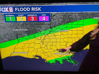
That is based on the rainfall potential forecast. However, we (both sides of Lake P.) are in a level 2 flood risk.
Look at the surge of low level moisture (60+ dew points) coming in from the SW. Satellite views already show sea fog off our coast (yellow arrows).
NWS isn't talking about dense fog later tonight as brisk SE winds should keep the clouds up off the ground. That will change later in the week where daily dense fog will be an issue. In the short term, Hannah laid out the time line for Sunday's showers.
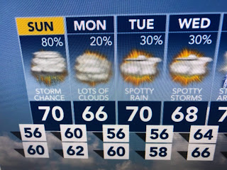
There coulld be a few morning showers, but the bulk of the rain will come in the late afternoon through evening time frames with the North Shore having the greater chances for heavier rainfall.
View this seven day forecast with a great degree of uncertainty based on the placement of the surface front. IF it sinks to our south, highs might be stuck in the 50s (40s North Shore). Or, it stays north and we are back to 70+ if we see any sunshine. The one certainty is we will have no freeze threat this next week. Finally,
Keep up on the heavy rain threat on Sunday PM into Sunday night, especially over the North Shore. I hate these stalling fronts as they often mean 'training' of radar echoes with storms moving along the same track over and over. Stay tuned!


No comments:
Post a Comment