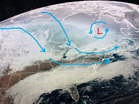
Our cool down is nothing like what's coming to the Great Lakes & New England.
The Polar Vortex will dip over them, but not dive down to us. This will keep the core of the bitter cold well to our north & east. Some parts of the North Shore will be near freezing on Saturday morning, but not south of Lake P. The buckle in the Jet stream over the East is caused by a return of storms to the West Coast.
The good news for us is the Polar Vortex will quickly dip over the Northeast & lift out keeping us protected from any hard freezes.
The top graphic is the upper flow with the Polar Vortex from this morning. The middle is valid for Friday morning with the bottom valid for Saturday morning. Clearly, you can see why this will be a brief blast of Arctic air for the folks up north. It will definitely be a Frigid Friday from D.C. to Philly, NYC to Boston. Many will dip to below zero.
We're watching for the upper trough over Texas to pass by early tomorrow clearing away our clouds and bringing back the sunshine.
Once the rain leaves tonight, the next 7 days will be mostly dry. We begin the weekend chilly, but by Sunday afternoon we flirt with near 70. Perfect parade weather. Stay tuned!


No comments:
Post a Comment