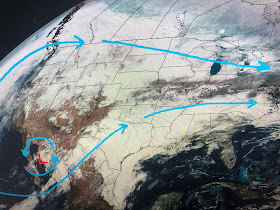
A sure sign that the daily higher sun angle is beginning to work is both Denver & Omaha hit 40+ in the sunshine. Down under the clouds, most of Texas was in the 30s.
An upper disturbance is lifting out of Mexico triggering widespread precipitation, much of it of the frozen (Snow, Sleet, Freezing rain) variety from Texas into Tennessee. We may see some periods of heavy rain here as this system races by with the highest rain chances after noon through early evening. Bruce showed the time line on his 5 pm broadcast.
If we briefly get into the warm air sector, temps could pop back into the 70s. Behind the front, seasonally colder air will make for a delightful weekend if you're dressed for it. A warm up begins by Sunday afternoon.
Once this next system departs early on Friday, it looks like a long stretch of sunshine is coming for the weekend into next week. Have to get through some PM storms on Thursday. SPC is downplaying any severe threat right now. Stay tuned!


No comments:
Post a Comment