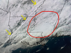
A strong cold front has passed Houston & Shreveport dropping their temperatures from the 70s into the 50s. There are some strong storms developing in the warm air sector, but the main threat should remain north of Lake P. as SPC's graphic indicates.
The current Tornado Watch is for areas well to our north. The current severe threat is different from the past couple of weeks as there is no closed upper disturbance, just an upper trough.
That should limit the upper level splitting of the jet stream. The yellow arrows indicate where the cold front is at 10:30 AM with the red circle highlighting the greatest threat for storms. Zack showed the timing of the front for tonight's parades.
Bottom line, if you are riding or going out to watch the parades, prepare for some rain and bring along a heavier jacket as it will turn colder behind the front. Models keep indicating a weakening trend as the line moves through us. I'll post again after 4 PM. Stay tuned!


No comments:
Post a Comment