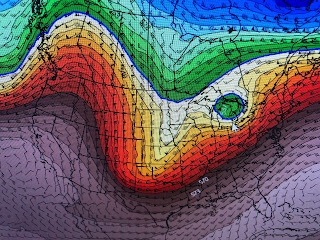
The next 3 days will see the warm up continue before another cold front arrives late Wednesday into early Thursday. The cold air will come back in surges with Friday & Saturday being windy & uncomfortably chilly. It starts with a storm over California today.
Looking ahead to next weekend has no rain, but very chilly temperatures with daytime highs in the upper 40s & lower 50s with 30s at night. Burrr! Let me show you why.
These are the upper air charts with the top view showing today's West coast trough over California dropping into New Mexico on Tuesday. The bottom is valid for Wednesday with the center over south Kansas. That low quickly lifts out on Thursday.
The top is valid for Thursday morning with the center in Michigan, but do you see the trough digging behind it? That sharpens the dip (middle) valid on Friday which will drive down the cold air. But it shouldn't last long as the bottom graphic is valid for next Sunday showing an upper ridge moving back over us with warmer air.
The below freezing line has retreated way north with a Spring preview coming this week.
It's time for Bailey's afternoon walk and I'm looking forward to being outside. Again, I'm concerned that the cold coming for Friday & Saturday might have to be revised downward as we get closer to the weekend. Very confident that it will be dry & cold. Stay tuned!


No comments:
Post a Comment