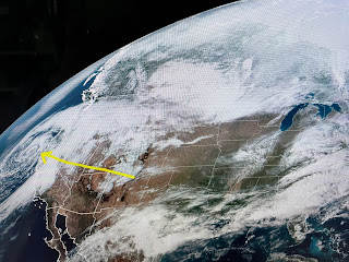
It is obvious where the main storm is off of California. We remain stuck under the southern stream WSW upper flow. The over night disturbance is to our east with a weaker one approaching form West Texas.
So with a cloud cover tomorrow, highs might struggle to get out of the high 60s, a welcomed change. But it won't last as the California system will ride across the Rockies and stay well to our north later this week with another upper West Coast trough to follow it.
I do see dew points back at Houston in the 40s & San Antonio in the 20s. That's really much drier good feel air.for the next 2 days. The 80s are back later this week.
OK, for you cold air geeks, you could live near my son(Rob) in Longmont, CO. He saw this at daybreak 2 days ago.


No comments:
Post a Comment