Tuesday, May 16, 2023

Despite Flooding Up North, No Need To Open Spillway This Year...

I was watching the networks hype up the "record" flooding from snow melt & Spring rains over the UPPER Mississippi water shed last week knowing full well that kind of flooding was not coming to us.  Why?  Because the lower Mississippi River receives 65-70% of its water from the Ohio River and that's not where the flooding occurred.  As the upper Mississippi combines with the Ohio River south of Cairo, Illinois, the Mississippi widens and becomes deeper.  That allows for that "record" flooding to easily spread out with any water surge flatten causing only minor rises.  Take a look at the Carrollton gauge.


 It has bounced back up from around 6 feet over the weekend and is projected to rise to near 9 feet later this week before cresting and falling again.  Typically in the past couple of years when the Spillway was opened, the River level was 15+ feet.  Not going to happen this year which is good news for folks fishing Lake Pontchartrain.


Our upper air pattern is changing once again as the upper high over the Southeast is pushed to the south by a digging East coast trough.  That will bring sever opportunities to receive needed rainfall.  Let's begin with tomorrow.


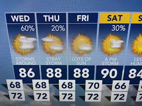
The first frontal boundary will increase our clouds and shower chances Wednesday, but it will struggle to get very far past us.


The Saturday front looks stronger and should push down to the coast.  Neither will bring cooler air, but it will be drier (less humid).


We reached 90 degrees for the second straight day, but the clouds & more numerous showers tomorrow should keep us in the 80s.  Have the umbrella ready.  Stay tuned!

No comments:

Post a Comment