As El Nino strengthens off the west coast of South America, we already see increased western winds (shear) streaming across the Caribbean. Another thing common with last year is several upper lows that tend to hinder any tropical development. Let's hope this trend can last for most of the 2023 season?
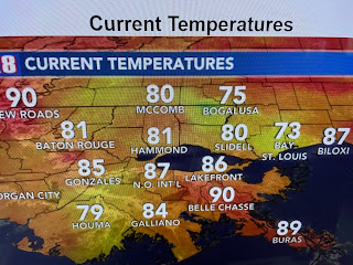
Our other big story is MSY reached 90 for the first time this year. That is no big deal and compares favorably with past years.
So now, when will the first name storm develop? IF you believe in computer models, not for the next 10-14 days.
Since the upper high, that kept us dry over the weekend, has weakened, look for daily rain chances enhanced by several weak frontal boundaries for the next couple of days. Hannah detailed the timing on her 4 PM program.
The stronger "front" arrives late Saturday with the better rain chances ahead of it. Drier air follows for Sunday & Monday.
We have reached the time of the year where fronts aren't cold anymore. But we'll take less humid anytime! Finally...
When smoke shows up on satellite views, you know it's a really big fire. Look at western Canada, especially western Alberta Province. Fires don't just happen unless they're caused by lightning. I make an easy prediction for all of the western states that saw abundant winter rain & snows. The moisture will produce lush vegetation that will become fuel for wildfires once the dry season sets in. Geez, I'm a genius! Stay tuned!


No comments:
Post a Comment