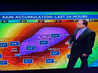
Most of the day was dry until the noon hour when storms began to develop triggered by an upper low over SW LA.
Last night Bruce's forecast called for 60% chance of rain and that's about what happened. These slow moving upper disturbances are difficult to track & predict and Wednesday could see a repeat.
Unlike the folks up north, our weather is not caused by moving cold fronts. We have to deal with these weak upper systems that can trigger excessive rainfall in a short time frame. I see the upper ridge building back over us later this week & that should mean lower rain chances.
If you have lived here all your life, you know it rains each day SOMEWHERE in the summertime. We're done with cold fronts. Now we have to refocus on the Tropics as we head towards hurricane season. Finally...


No comments:
Post a Comment